Geolocate

Alnön topographic map

Click on the map to display elevation.

About this map

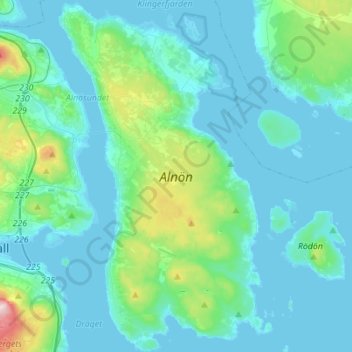
Name: Alnön topographic map, elevation, terrain.

Location: Alnön, Västernorrland County, Sweden (62.35265 17.36708 62.48069 17.52875)

Average elevation: 32 m

Minimum elevation: -2 m

Maximum elevation: 242 m

Other topographic maps

Click on a map to view its topography, its elevation and its terrain.

Stöde

Sweden > Västernorrland County

Average elevation: 102 m

Matfors

Sweden > Västernorrland County > Tuna District

Average elevation: 57 m

Vike

Sweden > Västernorrland County > Stigsjö District

Average elevation: 125 m

Vigge

Sweden > Västernorrland County

Average elevation: 238 m

Bye

Sweden > Västernorrland County > Hässjö District

Average elevation: 88 m

Runsvik

Sweden > Västernorrland County > Tuna District

Average elevation: 69 m

Maland

Sweden > Västernorrland County > Sundsvall

Average elevation: 37 m

Salteå

Sweden > Västernorrland County > Nora District

Average elevation: 61 m

Östbyn

Sweden > Västernorrland County > Holm District > Holm

Average elevation: 232 m

Gear up for your next adventure:

🧴Waterproofing Spray - Restore the DWR coating on jackets and tents
🧢Outdoor Cap - Protective cap for sun and rain during hikes
🛌Down Sleeping Bag - Superior warmth-to-weight ratio for cold nights
🧼Biodegradable Camp Soap - Environmentally friendly cleaning for gear and body
💡Compact LED Flashlight - Powerful and portable flashlight for outdoor use

As an Amazon Associate, this site earns from qualifying purchases at no extra cost to you.