
Spring Valley topographic map
Click on the map to display elevation.
About this map
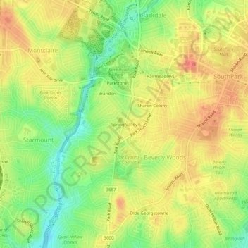
Name: Spring Valley topographic map, elevation, terrain.
Average elevation: 201 m
Minimum elevation: 166 m
Maximum elevation: 229 m
Other topographic maps
Click on a map to view its topography, its elevation and its terrain.
Tuckaseegee Park
United States > North Carolina > Mecklenburg County > Charlotte
Average elevation: 233 m
Carolina Harbor
United States > North Carolina > Mecklenburg County > Charlotte
Average elevation: 187 m
Providence Plantation
United States > North Carolina > Mecklenburg County > Charlotte
Average elevation: 205 m
Reedy Creek Regional Park
United States > North Carolina > Mecklenburg County > Charlotte
Average elevation: 229 m
Ballantyne's Backyard
United States > North Carolina > Mecklenburg County > Charlotte
Average elevation: 183 m
Mountainbrook
United States > North Carolina > Mecklenburg County > Charlotte
Average elevation: 202 m
Providence Plantation
United States > North Carolina > Mecklenburg County > Charlotte
Average elevation: 205 m
Providence Plantation
United States > North Carolina > Mecklenburg County > Charlotte
Average elevation: 205 m
Griffith Lakes
United States > North Carolina > Mecklenburg County > Charlotte
Average elevation: 244 m
Park on Wilgrove
United States > North Carolina > Mecklenburg County > Charlotte > Lakeland Hills
Average elevation: 232 m