
Make a donation
Gear up for your next adventure:
As an Amazon Associate, this site earns from qualifying purchases at no extra cost to you.
Providence Plantation topographic map
Click on the map to display elevation.
Make a donation
Gear up for your next adventure:
As an Amazon Associate, this site earns from qualifying purchases at no extra cost to you.
About this map
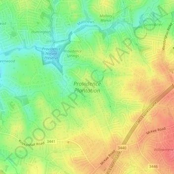
Name: Providence Plantation topographic map, elevation, terrain.
Average elevation: 205 m
Minimum elevation: 174 m
Maximum elevation: 234 m
Make a donation
Gear up for your next adventure:
As an Amazon Associate, this site earns from qualifying purchases at no extra cost to you.
Other topographic maps
Click on a map to view its topography, its elevation and its terrain.
Spring Valley
United States > North Carolina > Mecklenburg County > Charlotte
Average elevation: 201 m
Sharon Colony
United States > North Carolina > Mecklenburg County > Charlotte
Average elevation: 201 m
Make a donation
Gear up for your next adventure:
As an Amazon Associate, this site earns from qualifying purchases at no extra cost to you.
Make a donation
Gear up for your next adventure:
As an Amazon Associate, this site earns from qualifying purchases at no extra cost to you.
Mountainbrook
United States > North Carolina > Mecklenburg County > Charlotte
Average elevation: 202 m
Make a donation
Gear up for your next adventure:
As an Amazon Associate, this site earns from qualifying purchases at no extra cost to you.
Old Providence
United States > North Carolina > Mecklenburg County > Charlotte
Average elevation: 192 m
Make a donation
Gear up for your next adventure:
As an Amazon Associate, this site earns from qualifying purchases at no extra cost to you.
Montclaire South
United States > North Carolina > Mecklenburg County > Charlotte
Average elevation: 202 m
Providence Plantation
United States > North Carolina > Mecklenburg County > Charlotte > Providence Plantation
Average elevation: 200 m
Coulwood Hills
United States > North Carolina > Mecklenburg County > Charlotte > Coulwood Hills
Average elevation: 213 m
Make a donation
Gear up for your next adventure:
As an Amazon Associate, this site earns from qualifying purchases at no extra cost to you.