
Make a donation
Gear up for your next adventure:
As an Amazon Associate, this site earns from qualifying purchases at no extra cost to you.
Brixen im Thale topographic map
Click on the map to display elevation.
Make a donation
Gear up for your next adventure:
As an Amazon Associate, this site earns from qualifying purchases at no extra cost to you.
Brixen im Thale
Brixen im Thale liegt mit 794 Meter Seehöhe auf dem höchsten Punkt des Brixentals inmitten der Grasberge der Kitzbüheler Alpen. Das Besiedlungsgebiet erstreckt sich überwiegend nördlich der Eisenbahntrasse, wobei vereinzelte Fraktionen sich auch auf der südlichen Seite des Tales befinden. Südöstlich des Ortskerns zweigt das Brixenbachtal ab, welches dicht bewaldet ist und als Naturerholungsgebiet bekannt ist. Nördlich des Ortes befinden sich zahlreiche Berghänge, die als Sonnberg bezeichnet werden und vorwiegend landwirtschaftlich genutzt werden. Die Hänge südlich des Dorfes, die als Schattseitn bezeichnet werden, sind mit Ausnahme vereinzelter Almflächen Nadelwald.
Make a donation
Gear up for your next adventure:
As an Amazon Associate, this site earns from qualifying purchases at no extra cost to you.
About this map
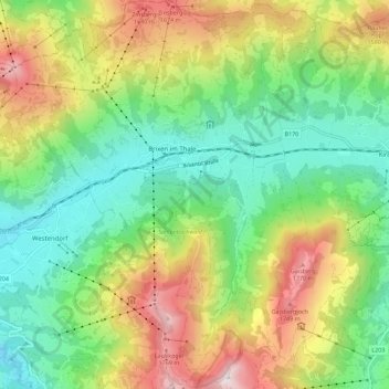
Name: Brixen im Thale topographic map, elevation, terrain.
Location: Brixen im Thale, Bezirk Kitzbühel, Tirol, 6364, Österreich (47.40255 12.20908 47.47845 12.29068)
Average elevation: 1,163 m
Minimum elevation: 705 m
Maximum elevation: 1,943 m
Make a donation
Gear up for your next adventure:
As an Amazon Associate, this site earns from qualifying purchases at no extra cost to you.
Other topographic maps
Click on a map to view its topography, its elevation and its terrain.
Scheffau
Österreich > Tirol > Bezirk Kitzbühel > Marktgemeinde St. Johann in Tirol
Average elevation: 939 m
Schafsiedel
Österreich > Tirol > Bezirk Kitzbühel > Hopfgarten im Brixental
Average elevation: 2,086 m
Make a donation
Gear up for your next adventure:
As an Amazon Associate, this site earns from qualifying purchases at no extra cost to you.
Außersalvenberg
Österreich > Tirol > Bezirk Kitzbühel > Westendorf > Feichten
Average elevation: 944 m
Make a donation
Gear up for your next adventure:
As an Amazon Associate, this site earns from qualifying purchases at no extra cost to you.
Schwaigerberg
Österreich > Tirol > Bezirk Kitzbühel > Westendorf > Unterwindau
Average elevation: 924 m
Make a donation
Gear up for your next adventure:
As an Amazon Associate, this site earns from qualifying purchases at no extra cost to you.
Hahnenkamm
Österreich > Tirol > Bezirk Kitzbühel > Kitzbühel
Über Kitzbühel erhebt sich der Hahnenkamm mit einer Höhe von 1712 m ü. A. Der eigentlich höchste Punkt am Hahnenkamm ist die Ehrenbachhöhe mit einer Höhe von 1802 m ü. A.
Average elevation: 1,444 m
Pillersee
Österreich > Tirol > Bezirk Kitzbühel > Sankt Ulrich am Pillersee > Brunnerau
Seine Entstehung verdankt der Pillersee einem Bergsturz vor etwa 15.000 Jahren, der den Abfluss in Höhe der Öfenschlucht unterbrach und so den Pillersee aufstaute.
Average elevation: 1,076 m
Make a donation
Gear up for your next adventure:
As an Amazon Associate, this site earns from qualifying purchases at no extra cost to you.
Reith bei Kitzbühel
Österreich > Tirol > Bezirk Kitzbühel > Gemeinde Reith bei Kitzbühel > Reith bei Kitzbühel
Average elevation: 914 m
Going
Österreich > Tirol > Bezirk Kitzbühel > Gemeinde Going am Wilden Kaiser > Going
Average elevation: 892 m
Make a donation
Gear up for your next adventure:
As an Amazon Associate, this site earns from qualifying purchases at no extra cost to you.
Markbachjoch
Österreich > Tirol > Bezirk Kitzbühel > Marktgemeinde Hopfgarten im Brixental
Average elevation: 1,178 m
Hahnenkamm
Österreich > Tirol > Bezirk Kitzbühel > Stadt Kitzbühel
Über Kitzbühel erhebt sich der Hahnenkamm mit einer Höhe von 1712 m ü. A. Der eigentlich höchste Punkt am Hahnenkamm ist die Ehrenbachhöhe mit einer Höhe von 1802 m ü. A.
Average elevation: 1,440 m
Weiberndorf
Österreich > Tirol > Bezirk Kitzbühel > Marktgemeinde St. Johann in Tirol > Weiberndorf
Average elevation: 788 m
Make a donation
Gear up for your next adventure:
As an Amazon Associate, this site earns from qualifying purchases at no extra cost to you.
Kelchsau
Österreich > Tirol > Bezirk Kitzbühel > Hopfgarten im Brixental > Kelchsau
Average elevation: 1,134 m
Steinplatte
Österreich > Tirol > Bezirk Kitzbühel > Waidring
Die Steinplatte liegt im Gemeindegebiet von Unken und Lofer im Saalachtal, Pinzgau und von Waidring im Bezirk Kitzbühel. Der Hauptgipfel (1869 m ü. A.) liegt am Westrand der Formation. Oberhalb des Strubtals erstreckt sich die etwa 1000 Höhenmeter hohe Sonnwand bis zum Grubhörndl (1747 m ü. A.) und die…
Average elevation: 1,432 m
Pillersee
Österreich > Tirol > Bezirk Kitzbühel > Sankt Ulrich am Pillersee > Brunnerau
Seine Entstehung verdankt der Pillersee einem Bergsturz vor etwa 15.000 Jahren, der den Abfluss in Höhe der Öfenschlucht unterbrach und so den Pillersee aufstaute.
Average elevation: 1,076 m
Make a donation
Gear up for your next adventure:
As an Amazon Associate, this site earns from qualifying purchases at no extra cost to you.
Make a donation
Gear up for your next adventure:
As an Amazon Associate, this site earns from qualifying purchases at no extra cost to you.
Buchensteinwand
Österreich > Tirol > Bezirk Kitzbühel > Sankt Ulrich am Pillersee
Average elevation: 1,109 m
Make a donation
Gear up for your next adventure:
As an Amazon Associate, this site earns from qualifying purchases at no extra cost to you.
Make a donation
Gear up for your next adventure:
As an Amazon Associate, this site earns from qualifying purchases at no extra cost to you.
Make a donation
Gear up for your next adventure:
As an Amazon Associate, this site earns from qualifying purchases at no extra cost to you.
Brixental
Österreich > Tirol > Bezirk Kitzbühel > Westendorf
Mit rund 24.000 Gästebetten, 1,68 Millionen Nächtigungen im Winter und 1,32 Millionen im Sommer (Stand 2018) stellt der Tourismus einen wichtigen Wirtschaftszweig dar. Die SkiWelt Wilder Kaiser – Brixental ist eines der größten Schigebiete Österreichs. Neben den zahlreichen Beherbergungsbetrieben und…
Average elevation: 998 m