
Make a donation
Gear up for your next adventure:
As an Amazon Associate, this site earns from qualifying purchases at no extra cost to you.
Kota Batu topographic map
Click on the map to display elevation.
Make a donation
Gear up for your next adventure:
As an Amazon Associate, this site earns from qualifying purchases at no extra cost to you.
Kota Batu
In the 19th century, the Dutch East Indies government developed Batu as a mountain resort. Villas and resort facilities were built in Batu during the period. Most of the topography of Batu city is dominated by highland and hilly terrain with valleys running down mountain slopes. In northern Batu, there is a dense forest, Raden Soerjo Forest Park, which is a protected forest area.[5]
Make a donation
Gear up for your next adventure:
As an Amazon Associate, this site earns from qualifying purchases at no extra cost to you.
About this map
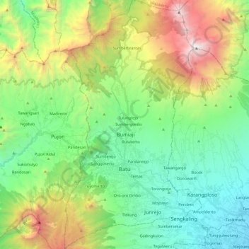
Name: Kota Batu topographic map, elevation, terrain.
Location: Kota Batu, East Java, Indonesia (-7.94107 112.47393 -7.72388 112.59499)
Average elevation: 1,365 m
Minimum elevation: 479 m
Maximum elevation: 3,308 m
Make a donation
Gear up for your next adventure:
As an Amazon Associate, this site earns from qualifying purchases at no extra cost to you.
Other topographic maps
Click on a map to view its topography, its elevation and its terrain.
Make a donation
Gear up for your next adventure:
As an Amazon Associate, this site earns from qualifying purchases at no extra cost to you.