
Elizabethtown-Kitley topographic map
Click on the map to display elevation.
About this map
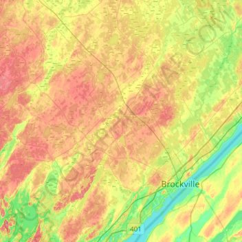
Name: Elizabethtown-Kitley topographic map, elevation, terrain.
Average elevation: 111 m
Minimum elevation: 72 m
Maximum elevation: 156 m
Leeds and Grenville Counties trails, hiking, mountain biking, running and outdoor activities
Other topographic maps
Click on a map to view its topography, its elevation and its terrain.
Mallorytown Landing
Canada > Ontario > Leeds and Grenville Counties > Front of Yonge
Average elevation: 86 m
Groveton
Canada > Ontario > Leeds and Grenville Counties > Edwardsburgh/Cardinal
Average elevation: 99 m
Spencerville
Canada > Ontario > Leeds and Grenville Counties > Edwardsburgh/Cardinal
Average elevation: 99 m
Toledo
Canada > Ontario > Leeds and Grenville Counties > Elizabethtown-Kitley
Average elevation: 121 m
Seeleys Bay
Canada > Ontario > Leeds and Grenville Counties > Leeds and the Thousand Islands > Seeley's Bay
Average elevation: 105 m
Waterton
Canada > Ontario > Leeds and Grenville Counties > Leeds and the Thousand Islands > Waterton
Average elevation: 97 m
Spectacle Lake
Canada > Ontario > Leeds and Grenville Counties > Rideau Lakes
Average elevation: 189 m
Motts Mills
Canada > Ontario > Leeds and Grenville Counties > Elizabethtown-Kitley
Average elevation: 126 m
Little Crosby Lake
Canada > Ontario > Leeds and Grenville Counties > Rideau Lakes
Average elevation: 166 m
Johnstown
Canada > Ontario > Leeds and Grenville Counties > Edwardsburgh/Cardinal
Average elevation: 83 m
Lansdowne
Canada > Ontario > Leeds and Grenville Counties > Leeds and the Thousand Islands
Average elevation: 101 m
Harvey Island
Canada > Ontario > Leeds and Grenville Counties > Elizabethtown-Kitley
Average elevation: 111 m
Cardinal
Canada > Ontario > Leeds and Grenville Counties > Edwardsburgh/Cardinal
Average elevation: 82 m
Tincap
Canada > Ontario > Leeds and Grenville Counties > Elizabethtown-Kitley
Average elevation: 113 m
Actons Corners
Canada > Ontario > Leeds and Grenville Counties > North Grenville
Average elevation: 97 m
Frankville
Canada > Ontario > Leeds and Grenville Counties > Elizabethtown-Kitley
Average elevation: 118 m
Merrickville
Canada > Ontario > Leeds and Grenville Counties > Merrickville-Wolford
Average elevation: 114 m
Bells Crossing
Canada > Ontario > Leeds and Grenville Counties > Elizabethtown-Kitley
Average elevation: 118 m
Junetown
Canada > Ontario > Leeds and Grenville Counties > Leeds and the Thousand Islands
Average elevation: 110 m
Lyndhurst
Canada > Ontario > Leeds and Grenville Counties > Leeds and the Thousand Islands
Average elevation: 98 m
Seeley's Bay
Canada > Ontario > Leeds and Grenville Counties > Leeds and the Thousand Islands
Average elevation: 106 m
Crosby
Canada > Ontario > Leeds and Grenville Counties > Rideau Lakes > Crosby
Average elevation: 128 m
Greenbush
Canada > Ontario > Leeds and Grenville Counties > Elizabethtown-Kitley > Greenbush
Average elevation: 120 m
Oxford Mills
Canada > Ontario > Leeds and Grenville Counties > North Grenville
Average elevation: 103 m
Outlet
Canada > Ontario > Leeds and Grenville Counties > Leeds and the Thousand Islands
Average elevation: 97 m
Quabbin
Canada > Ontario > Leeds and Grenville Counties > Leeds and the Thousand Islands
Average elevation: 97 m
Rochester Bay
Canada > Ontario > Leeds and Grenville Counties > Leeds and the Thousand Islands
Average elevation: 74 m
Codfish Island
Canada > Ontario > Leeds and Grenville Counties > Leeds and the Thousand Islands
Average elevation: 79 m
Glen Buell
Canada > Ontario > Leeds and Grenville Counties > Elizabethtown-Kitley
Average elevation: 120 m
Cardinal
Canada > Ontario > Leeds and Grenville Counties > Edwardsburgh/Cardinal
Average elevation: 82 m
Why Island
Canada > Ontario > Leeds and Grenville Counties > Leeds and the Thousand Islands
Average elevation: 92 m
Seeleys Bay
Canada > Ontario > Leeds and Grenville Counties > Leeds and the Thousand Islands > Seeley's Bay
Average elevation: 105 m
Outlet
Canada > Ontario > Leeds and Grenville Counties > Leeds and the Thousand Islands
Average elevation: 97 m