
Make a donation
Gear up for your next adventure:
As an Amazon Associate, this site earns from qualifying purchases at no extra cost to you.
Erongarícuaro topographic map
Click on the map to display elevation.
Make a donation
Gear up for your next adventure:
As an Amazon Associate, this site earns from qualifying purchases at no extra cost to you.
About this map
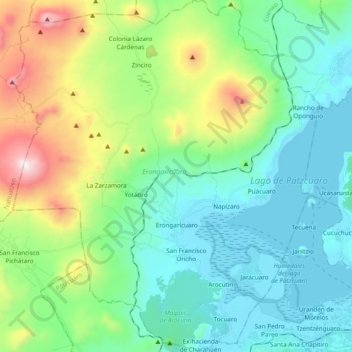
Name: Erongarícuaro topographic map, elevation, terrain.
Location: Erongarícuaro, Michoacán, 61630, Mexico (19.52184 -101.81030 19.70293 -101.64227)
Average elevation: 2,359 m
Minimum elevation: 2,033 m
Maximum elevation: 3,253 m
Make a donation
Gear up for your next adventure:
As an Amazon Associate, this site earns from qualifying purchases at no extra cost to you.
Other topographic maps
Click on a map to view its topography, its elevation and its terrain.
Make a donation
Gear up for your next adventure:
As an Amazon Associate, this site earns from qualifying purchases at no extra cost to you.
Ihuatzio
Mexico > Michoacán > Tzintzuntzan
Ihuatzio is located on the southeast of the Lake Pátzcuaro, about 8 kilometers southwest of the town center of Tzintzuntzan. Its average elevation is 2,052 meters above the sea level.
Average elevation: 2,052 m
Make a donation
Gear up for your next adventure:
As an Amazon Associate, this site earns from qualifying purchases at no extra cost to you.