
Deer Lake topographic map
Interactive map
Click on the map to display elevation.
About this map
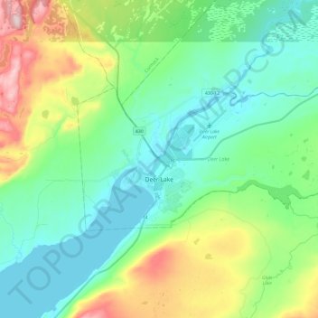
Name: Deer Lake topographic map, elevation, terrain.
Location: Deer Lake, Newfoundland, Newfoundland and Labrador, Canada (49.15801 -57.49314 49.22791 -57.25646)
Average elevation: 101 m
Minimum elevation: 3 m
Maximum elevation: 365 m
Newfoundland and Labrador trails, hiking, mountain biking, running and outdoor activities
Other topographic maps
Click on a map to view its topography, its elevation and its terrain.
Avalon Peninsula
Canada > Newfoundland and Labrador > Spaniard's Bay > Tilton
Average elevation: 157 m
Portugal Cove - St. Philips
Canada > Newfoundland and Labrador > Portugal Cove - St. Philips
Average elevation: 128 m
Signal Hill National Historic Site
Canada > Newfoundland and Labrador > St. John's
Average elevation: 29 m
Cape St. George
Canada > Newfoundland and Labrador > Cape St. George > Cape St. George
Average elevation: 68 m
Ferryland Head
Canada > Newfoundland and Labrador > unincorporated Newfoundland > Ferryland
Average elevation: 1 m
Corner Brook
Canada > Newfoundland and Labrador > unincorporated Newfoundland > Corner Brook
Average elevation: 163 m
Middle Cove
Canada > Newfoundland and Labrador > Logy Bay-Middle Cove-Outer Cove
Average elevation: 41 m