
Torbay topographic map
Interactive map
Click on the map to display elevation.
About this map
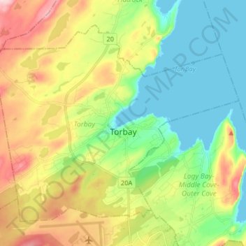
Name: Torbay topographic map, elevation, terrain.
Location: Torbay, Newfoundland, Newfoundland and Labrador, Canada (47.62557 -52.79599 47.69576 -52.66568)
Average elevation: 82 m
Minimum elevation: -1 m
Maximum elevation: 221 m
Newfoundland and Labrador trails, hiking, mountain biking, running and outdoor activities
Other topographic maps
Click on a map to view its topography, its elevation and its terrain.
Avalon Peninsula
Canada > Newfoundland and Labrador > Spaniard's Bay > Tilton
Average elevation: 157 m
Signal Hill National Historic Site
Canada > Newfoundland and Labrador > St. John's
Average elevation: 29 m
Corner Brook
Canada > Newfoundland and Labrador > unincorporated Newfoundland > Corner Brook
Average elevation: 163 m
Middle Cove
Canada > Newfoundland and Labrador > Logy Bay-Middle Cove-Outer Cove
Average elevation: 41 m