Geolocate

Bullitt County topographic map

Interactive map

Click on the map to display elevation.

About this map

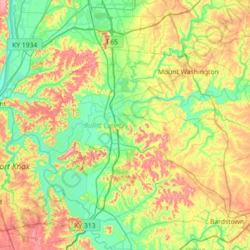
Name: Bullitt County topographic map, elevation, terrain.

Location: Bullitt County, Kentucky, United States (37.80998 -85.93801 38.11817 -85.42905)

Average elevation: 183 m

Minimum elevation: 122 m

Maximum elevation: 299 m

Other topographic maps

Click on a map to view its topography, its elevation and its terrain.

Knoxville

United States > Kentucky > Pendleton County

Average elevation: 251 m

Pansy

United States > Kentucky > Harlan County

Average elevation: 602 m

Zion Hill

United States > Kentucky > Scott County

Average elevation: 260 m

Confluence

United States > Kentucky > Leslie County

Average elevation: 336 m

Robinson Creek

United States > Kentucky > Pike County

Average elevation: 337 m

Redhouse

United States > Kentucky > Madison County

Average elevation: 248 m

New

United States > Kentucky > Owen County

Average elevation: 243 m

Eastern

United States > Kentucky > Floyd County

Average elevation: 274 m

Mullins Point

United States > Kentucky > Wolfe County

Average elevation: 289 m

Moorland

United States > Kentucky > Jefferson County > Lyndon

Average elevation: 193 m

Pineville

United States > Kentucky > Bell County > Pineville > Pineville

Average elevation: 453 m

Pitts Point

United States > Kentucky > Pitts Point

Average elevation: 155 m

Kingston

United States > Kentucky > Lexington > Kingston

Average elevation: 297 m

Whitaker

United States > Kentucky > Letcher County > Whitaker

Average elevation: 469 m