
Prentice topographic map
Interactive map
Click on the map to display elevation.
About this map
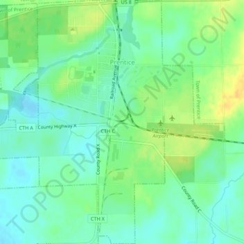
Name: Prentice topographic map, elevation, terrain.
Location: Prentice, Price County, Wisconsin, 54556, United States (45.52424 -90.31011 45.55353 -90.26898)
Average elevation: 473 m
Minimum elevation: 462 m
Maximum elevation: 488 m
Other topographic maps
Click on a map to view its topography, its elevation and its terrain.
Kennan
United States > Wisconsin > Price County
Kennan, Price County, Wisconsin, United States
Average elevation: 457 m
Dover
United States > Wisconsin > Price County
Dover, Town of Emery, Price County, Wisconsin, United States
Average elevation: 504 m
Worcester
United States > Wisconsin > Price County
Worcester, Town of Hackett, Price County, Wisconsin, United States
Average elevation: 486 m
Ogema
United States > Wisconsin > Price County
Ogema, Town of Ogema, Price County, Wisconsin, United States
Average elevation: 477 m
Smith Lake County Park
United States > Wisconsin > Price County > Park Falls
Smith Lake County Park, Park Falls, Town of Eisenstein, Price County, Wisconsin, 54896, United States
Average elevation: 451 m
Phillips
United States > Wisconsin > Price County
Phillips, Price County, Wisconsin, 54555, United States
Average elevation: 446 m
Catawba
United States > Wisconsin > Price County
Catawba, Price County, Wisconsin, United States
Average elevation: 455 m
Kennedy
United States > Wisconsin > Price County > Kennedy
Kennedy, Town of Lake, Price County, Wisconsin, United States
Average elevation: 448 m
Timms Hill
United States > Wisconsin > Price County
Timms Hill, Town of Hill, Price County, Wisconsin, 54459, United States
Average elevation: 553 m