Geolocate

Phillips topographic map

Click on the map to display elevation.

About this map

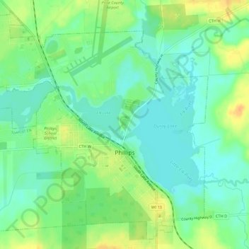
Name: Phillips topographic map, elevation, terrain.

Location: Phillips, Price County, Wisconsin, 54555, United States (45.67785 -90.43359 45.71243 -90.37982)

Average elevation: 446 m

Minimum elevation: 433 m

Maximum elevation: 465 m

Other topographic maps

Click on a map to view its topography, its elevation and its terrain.

Dover

United States > Wisconsin > Price County

Average elevation: 504 m

Ogema

United States > Wisconsin > Price County

Average elevation: 477 m

Worcester

United States > Wisconsin > Price County

Average elevation: 486 m

Kennedy

United States > Wisconsin > Price County > Kennedy

Average elevation: 448 m

Gear up for your next adventure:

📷Outdoor Action Camera - Capture high-elevation views and rugged adventures
🥫Freeze-Dried Meals - Lightweight, high-calorie nutrition for multi-day treks
🗺️Topographic Maps - Detailed maps to explore trails, mountains, and wilderness areas
🧭Orienteering Kit - Tools for map reading and navigation in the wild
🥾Waterproof Trail Shoes - Shoes designed to handle wet terrain

As an Amazon Associate, this site earns from qualifying purchases at no extra cost to you.