Geolocate

Kennan topographic map

Click on the map to display elevation.

About this map

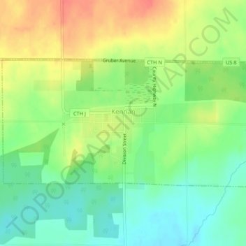
Name: Kennan topographic map, elevation, terrain.

Location: Kennan, Price County, Wisconsin, United States (45.52255 -90.60737 45.53747 -90.56631)

Average elevation: 457 m

Minimum elevation: 433 m

Maximum elevation: 485 m

Other topographic maps

Click on a map to view its topography, its elevation and its terrain.

Dover

United States > Wisconsin > Price County

Average elevation: 504 m

Kennedy

United States > Wisconsin > Price County > Kennedy

Average elevation: 448 m

Ogema

United States > Wisconsin > Price County

Average elevation: 477 m

Worcester

United States > Wisconsin > Price County

Average elevation: 486 m

Gear up for your next adventure:

🧭GPS Outdoor Watch - Smart watch for navigation and fitness tracking in nature
🕯️Camping Lantern - Illuminates your entire campsite with high-efficiency LEDs
🥫Freeze-Dried Meals - Lightweight, high-calorie nutrition for multi-day treks
📷Outdoor Action Camera - Capture high-elevation views and rugged adventures
Bushcraft Tarp - Versatile emergency shelter or gear protection

As an Amazon Associate, this site earns from qualifying purchases at no extra cost to you.