Geolocate

Dover topographic map

Click on the map to display elevation.

About this map

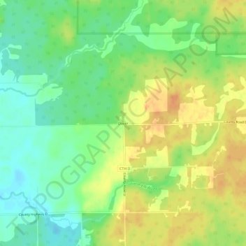
Name: Dover topographic map, elevation, terrain.

Location: Dover, Town of Emery, Price County, Wisconsin, United States (45.65162 -90.20765 45.69162 -90.16765)

Average elevation: 504 m

Minimum elevation: 487 m

Maximum elevation: 521 m

Other topographic maps

Click on a map to view its topography, its elevation and its terrain.

Phillips

United States > Wisconsin > Price County

Average elevation: 446 m

Park Falls

United States > Wisconsin > Price County

Average elevation: 462 m

Kennan

United States > Wisconsin > Price County

Average elevation: 457 m

Catawba

United States > Wisconsin > Price County

Average elevation: 455 m

Gear up for your next adventure:

🥾Approach Boots - Comfortable boots for hiking and climbing approaches
🥾Waterproof Trail Shoes - Shoes designed to handle wet terrain
❄️Traction Ice Cleats - Slip-on spikes for icy trails and winter hiking
🎒Fully Waterproof Backpack - Total protection for photography gear and electronics
🥾Waterproof Hiking Boots - Essential footwear for rugged terrain and wet Canadian trails

As an Amazon Associate, this site earns from qualifying purchases at no extra cost to you.