Geolocate

Montcalm topographic map

Interactive map

Click on the map to display elevation.

About this map

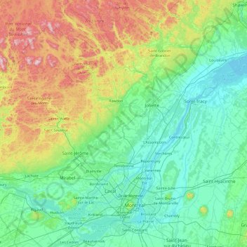
Name: Montcalm topographic map, elevation, terrain.

Location: Montcalm, Lanaudière, Quebec, J0K 2L0, Canada (45.28357 -74.29305 46.56357 -73.01305)

Average elevation: 179 m

Minimum elevation: 1 m

Maximum elevation: 905 m

Quebec trails, hiking, mountain biking, running and outdoor activities

Other topographic maps

Click on a map to view its topography, its elevation and its terrain.

Quebec

Canada > Quebec > Urban agglomeration of Québec

Quebec City was built on the north bank of the Saint Lawrence River, where it narrows and meets the mouth of the Saint-Charles River. Old Quebec is located on top and at the foot of Cap-Diamant, which is on the eastern edge of a plateau called the promontory of Quebec (Quebec hill). Because of this topographic…

Average elevation: 117 m

Saint-Lazare

Canada > Quebec > Vaudreuil-Soulanges

Average elevation: 57 m

Gatineau

Canada > Quebec

Gatineau is located in southwestern Quebec, on the northern bank of the Gatineau River. It is situated at an elevation of around 50 m (164.042 ft) The Gatineau Hills are the foothills of the Laurentian Mountains and located in the region. It is also the location of the second largest urban park in the world.…

Average elevation: 127 m

Sainte-Julie

Canada > Quebec > Marguerite-D'Youville

Average elevation: 37 m

Saint-Roch-de-Mékinac

Canada > Quebec > Mékinac

Average elevation: 261 m

Mont-Tremblant

Canada > Quebec > Les Laurentides

The city is dominated by Mont Tremblant with an altitude of 968m which is one of the highest peaks in southern Quebec.

Average elevation: 358 m

Sherbrooke

Canada > Quebec

Average elevation: 232 m

Masson-Angers

Canada > Quebec > Gatineau

Average elevation: 92 m

Quebec

Canada > Quebec > Urban agglomeration of Québec

Quebec City was built on the north bank of the Saint Lawrence River, where it narrows and meets the mouth of the Saint-Charles River. Old Quebec is located on top and at the foot of Cap-Diamant, which is on the eastern edge of a plateau called the promontory of Quebec (Quebec hill). Because of this topographic…

Average elevation: 117 m

Arrondissement de Chicoutimi

Canada > Quebec > Saguenay

Average elevation: 177 m

Rivière Barley

Canada > Quebec > Charlevoix > Lac-Pikauba

Average elevation: 778 m

Laval (administrative region)

Canada > Quebec

Average elevation: 42 m

Manicouagan

Canada > Quebec

Average elevation: 437 m

Outaouais

Canada > Quebec

Average elevation: 318 m

Ormstown

Canada > Quebec > Le Haut-Saint-Laurent

Average elevation: 63 m

Tadoussac

Canada > Quebec > La Haute-Côte-Nord

Average elevation: 140 m

Anticosti Island

Canada > Quebec

Topographically, Anticosti Island can be divided into three distinct regions: two lowland areas, rarely exceeding 150 metres (490 ft) in elevation, in the eastern and western thirds of the island linked along the coast; and a central highland forming a plateau that rises to just over 300 m (980 ft). This…

Average elevation: 30 m

Trois-Rives

Canada > Quebec > Mékinac

Average elevation: 287 m

Mayo

Canada > Quebec > Papineau

Average elevation: 207 m

Saint-Côme

Canada > Quebec > Matawinie

Average elevation: 367 m

Lac Brigitte

Canada > Quebec > Jamésie > Eeyou Istchee James Bay

Average elevation: 414 m

Louiseville

Canada > Quebec > Maskinongé (MRC)

Average elevation: 17 m

Les Coteaux

Canada > Quebec > Vaudreuil-Soulanges

Average elevation: 47 m

Potton

Canada > Quebec > Memphrémagog

Average elevation: 321 m

Estérel

Canada > Quebec > Les Pays-d'en-Haut

Average elevation: 370 m

La Malbaie

Canada > Quebec > Charlevoix-Est

Average elevation: 312 m

Lac a la Truite

Canada > Quebec > Pontiac > Sheenboro

Average elevation: 271 m

Lac Ladd

Canada > Quebec > Manicouagan > Rivière-aux-Outardes

Average elevation: 512 m

Drummondville

Canada > Quebec > Drummond

Average elevation: 86 m

Saint-Adelme

Canada > Quebec > La Matanie

Average elevation: 237 m

Lac Mikiwam

Canada > Quebec > Argenteuil > Harrington

Average elevation: 282 m

Lac Bongard

Canada > Quebec > Pontiac > Rapides-des-Joachims

Average elevation: 321 m

Natashquan

Canada > Quebec > Minganie

Average elevation: 52 m

Lac aux Cossins

Canada > Quebec > Shawinigan

Average elevation: 216 m

Lac-Saguay

Canada > Quebec > Antoine-Labelle

Average elevation: 344 m

Denholm

Canada > Quebec > La Vallée-de-la-Gatineau

Average elevation: 279 m

Rawdon

Canada > Quebec > Matawinie

Average elevation: 197 m

Saint-Tite

Canada > Quebec > Mékinac

Average elevation: 174 m

Saint-Calixte

Canada > Quebec > Montcalm

Average elevation: 230 m

Notre-Dame-des-Bois

Canada > Quebec > Le Granit

Average elevation: 593 m

Huntingdon

Canada > Quebec > Le Haut-Saint-Laurent

Average elevation: 50 m

Lac-Saint-Joseph

Canada > Quebec > La Jacques-Cartier

Average elevation: 232 m

Baie-Saint-Paul

Canada > Quebec > Charlevoix

Average elevation: 287 m

Bras Saint-Nicolas

Canada > Quebec > L'Islet (MRC) > L'Islet

Average elevation: 257 m

Saint-Benoît-Labre

Canada > Quebec > Beauce-Sartigan

Average elevation: 317 m

Boisé de l'étrier

Canada > Quebec > Gatineau

Average elevation: 56 m

La Minerve

Canada > Quebec > Les Laurentides

Average elevation: 298 m

Lac à Joram

Canada > Quebec > La Matapédia > Sainte-Irène

Average elevation: 498 m

Lac-Saint-Jean-Est

Canada > Quebec

Average elevation: 285 m

L'Isle-aux-Coudres

Canada > Quebec > Charlevoix

Average elevation: 14 m

Sainte-Hedwidge

Canada > Quebec > Le Domaine-du-Roy

Average elevation: 317 m

Lévis

Canada > Quebec

Average elevation: 96 m

Boisbriand

Canada > Quebec > Thérèse-De Blainville

Average elevation: 39 m

Lac-Lenôtre

Canada > Quebec > La Vallée-de-la-Gatineau

Average elevation: 404 m

Lac Chapleau

Canada > Quebec > Les Laurentides > La Minerve

Average elevation: 290 m

Saint-Côme

Canada > Quebec > Matawinie

Average elevation: 367 m

Saint-Jérôme

Canada > Quebec > La Rivière-du-Nord

Average elevation: 132 m

Richelieu

Canada > Quebec > Rouville

Average elevation: 32 m

Yamaska

Canada > Quebec > Pierre-De Saurel

Average elevation: 16 m

Victoriaville

Canada > Quebec > Arthabaska

Average elevation: 146 m

Lac des Graines

Canada > Quebec > Charlevoix-Est > Saint-Siméon

Average elevation: 154 m

Saint-Sauveur

Canada > Quebec > Les Pays-d'en-Haut

Average elevation: 294 m

Lac-Nilgaut

Canada > Quebec > Pontiac

Average elevation: 344 m

Saint-Tite

Canada > Quebec > Mékinac

Average elevation: 174 m

Saint Lawrence River

Canada > Quebec > Montreal

Average elevation: 14 m

Sainte-Julienne

Canada > Quebec > Montcalm

Average elevation: 123 m

Rivière de la Petite Nation

Canada > Quebec > Papineau

Average elevation: 274 m

Candiac

Canada > Quebec > Roussillon

Average elevation: 26 m

Mont-Tremblant

Canada > Quebec > Les Laurentides

The city is dominated by Mont Tremblant with an altitude of 968m which is one of the highest peaks in southern Quebec.

Average elevation: 358 m