Geolocate

Torino topographic map

Interactive map

Click on the map to display elevation.

About this map

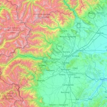
Name: Torino topographic map, elevation, terrain.

Location: Torino, Piedmont, Italy (44.71376 6.62727 45.60232 8.15187)

Average elevation: 1,132 m

Minimum elevation: 109 m

Maximum elevation: 3,996 m

Other topographic maps

Click on a map to view its topography, its elevation and its terrain.

Cavoretto

Italy > Piedmont > Torino > Turin

Average elevation: 337 m

Valle Mosso

Italy > Piedmont > Biella

Average elevation: 592 m

Sias

Italy > Piedmont > Torino > Nomaglio

Average elevation: 869 m

Artic

Italy > Piedmont > Cuneo > Frabosa Soprana

Average elevation: 1,093 m

Li Rochette

Italy > Piedmont > Torino > Caselette

Average elevation: 530 m

Spinetta Marengo

Italy > Piedmont > Alessandria > Alessandria

Average elevation: 98 m

Cà Nova

Italy > Piedmont > Biella > Pray

Average elevation: 525 m

Magnus

Italy > Piedmont > Torino > Lessolo

Average elevation: 334 m