Geolocate

Brome-Missisquoi topographic map

Interactive map

Click on the map to display elevation.

About this map

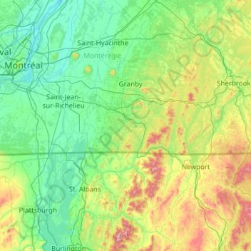
Name: Brome-Missisquoi topographic map, elevation, terrain.

Location: Brome-Missisquoi, Montérégie, Quebec, J2K 3J6, Canada (44.51959 -73.40030 45.79959 -72.12030)

Average elevation: 191 m

Minimum elevation: 3 m

Maximum elevation: 1,254 m

Quebec trails, hiking, mountain biking, running and outdoor activities

Other topographic maps

Click on a map to view its topography, its elevation and its terrain.

Saint-Lazare

Canada > Quebec > Vaudreuil-Soulanges

Average elevation: 57 m

Laval (administrative region)

Canada > Quebec

Average elevation: 42 m

Mont-Tremblant

Canada > Quebec > Les Laurentides

The city is dominated by Mont Tremblant with an altitude of 968m which is one of the highest peaks in southern Quebec.

Average elevation: 358 m

Quebec

Canada > Quebec > Urban agglomeration of Québec

Quebec City was built on the north bank of the Saint Lawrence River, where it narrows and meets the mouth of the Saint-Charles River. Old Quebec is located on top and at the foot of Cap-Diamant, which is on the eastern edge of a plateau called the promontory of Quebec (Quebec hill). Because of this topographic…

Average elevation: 117 m

Sherbrooke

Canada > Quebec

Average elevation: 232 m

Gatineau

Canada > Quebec

Gatineau is located in southwestern Quebec, on the northern bank of the Gatineau River. It is situated at an elevation of around 50 m (164.042 ft) The Gatineau Hills are the foothills of the Laurentian Mountains and located in the region. It is also the location of the second largest urban park in the world.…

Average elevation: 127 m

Lac-Nilgaut

Canada > Quebec > Pontiac

Average elevation: 344 m

Saint-Jérôme

Canada > Quebec > La Rivière-du-Nord

Average elevation: 132 m

Lac des Graines

Canada > Quebec > Charlevoix-Est > Saint-Siméon

Average elevation: 154 m

Mont-Tremblant

Canada > Quebec > Les Laurentides

The city is dominated by Mont Tremblant with an altitude of 968m which is one of the highest peaks in southern Quebec.

Average elevation: 358 m

Sainte-Julienne

Canada > Quebec > Montcalm

Average elevation: 123 m

Rivière de la Petite Nation

Canada > Quebec > Papineau

Average elevation: 274 m

Pont-Rouge

Canada > Quebec > Portneuf (MRC)

Average elevation: 117 m

Candiac

Canada > Quebec > Roussillon

Average elevation: 26 m

Kangiqsujuaq (Village)

Canada > Quebec > Kativik

Average elevation: 107 m

Lac Vlimeux

Canada > Quebec > Mékinac > Saint-Roch-de-Mékinac

Average elevation: 329 m

Témiscaming

Canada > Quebec > Témiscamingue

Average elevation: 309 m

Saint-Pierre-Baptiste

Canada > Quebec > L'Érable

Average elevation: 281 m

Saint-Tite

Canada > Quebec > Mékinac

Average elevation: 174 m

Belleterre

Canada > Quebec > Témiscamingue

Average elevation: 333 m

Les Collines-de-l'Outaouais

Canada > Quebec

Average elevation: 177 m

Princeville

Canada > Quebec > L'Érable

Average elevation: 143 m

Lac Louisa

Canada > Quebec > Le Fjord-du-Saguenay > Mont-Valin

Average elevation: 615 m

Malartic

Canada > Quebec > La Vallée-de-l'Or

Average elevation: 318 m

Arrondissement de Chicoutimi

Canada > Quebec > Saguenay

Average elevation: 189 m

Kawawachikamach (Village)

Canada > Quebec

Average elevation: 497 m

Sainte-Rita

Canada > Quebec > Les Basques

Average elevation: 275 m

Amos

Canada > Quebec > Abitibi > Amos

Average elevation: 313 m

Mirabel

Canada > Quebec

Average elevation: 88 m

Alma

Canada > Quebec > Lac-Saint-Jean-Est

Average elevation: 129 m

Saint-Gabriel

Canada > Quebec > D'Autray

Average elevation: 165 m

Sainte-Marthe

Canada > Quebec > Vaudreuil-Soulanges

Average elevation: 77 m

Gatineau

Canada > Quebec

Gatineau is located in southwestern Quebec, on the northern bank of the Gatineau River. It is situated at an elevation of around 50 metres (160 feet) The Gatineau Hills are the foothills of the Laurentian Mountains and located in the region. It is also the location of the third largest urban park in the world.…

Average elevation: 127 m

Wemindji (Village)

Canada > Quebec > Jamésie

Average elevation: 11 m

Howick

Canada > Quebec > Le Haut-Saint-Laurent

Average elevation: 39 m

Gaspé Peninsula

Canada > Quebec

Average elevation: 190 m

Sept-Îles

Canada > Quebec > Sept-Rivières

Average elevation: 189 m

Eastmain (Village)

Canada > Quebec > Jamésie

Average elevation: 81 m

Baie-Saint-Paul

Canada > Quebec > Charlevoix

Average elevation: 287 m

Lac Marier

Canada > Quebec > Les Laurentides > Labelle

Average elevation: 321 m

Buckingham

Canada > Quebec > Gatineau

Average elevation: 124 m

Waskaganish (Village)

Canada > Quebec > Jamésie

Average elevation: 33 m

Robert-Bourassa dam

Canada > Quebec > Jamésie

Average elevation: 142 m

Marston

Canada > Quebec > Le Granit

Average elevation: 484 m

Roxton Pond

Canada > Quebec > La Haute-Yamaska

Average elevation: 131 m

Rivière Lepellé

Canada > Quebec

Average elevation: 272 m

Saint-Honoré

Canada > Quebec > Le Fjord-du-Saguenay

Average elevation: 151 m

La Pocatière

Canada > Quebec > Kamouraska (MRC)

Average elevation: 23 m

Lac Bonin

Canada > Quebec > Shawinigan

Average elevation: 294 m

Havre-Saint-Pierre

Canada > Quebec > Minganie

Average elevation: 135 m

Granby

Canada > Quebec > La Haute-Yamaska

Average elevation: 121 m

Lacolle

Canada > Quebec > Le Haut-Richelieu

Average elevation: 47 m

Wentworth

Canada > Quebec > Argenteuil

Average elevation: 323 m

La Haute-Côte-Nord

Canada > Quebec

Average elevation: 348 m

Saint Lawrence River

Canada > Quebec > Montreal

Average elevation: 14 m

Campbell's Bay

Canada > Quebec > Pontiac

Average elevation: 128 m

Saint-Sauveur

Canada > Quebec > Les Pays-d'en-Haut

Average elevation: 294 m

Lac-des-Écorces

Canada > Quebec > Antoine-Labelle

Average elevation: 277 m

Scott

Canada > Quebec > La Nouvelle-Beauce

Average elevation: 178 m

Portneuf (MRC)

Canada > Quebec

Average elevation: 316 m

Black and White

Canada > Quebec > Les Laurentides > Montcalm

Average elevation: 296 m

Lac Dainava

Canada > Quebec > Argenteuil > Mille-Isles

Average elevation: 310 m

Rouyn-Noranda

Canada > Quebec

Average elevation: 307 m

Akulivik (Village)

Canada > Quebec > Kativik

Average elevation: 15 m

Saint-Roch-des-Aulnaies

Canada > Quebec > L'Islet (MRC)

Average elevation: 37 m

La Pêche

Canada > Quebec > Les Collines-de-l'Outaouais

Average elevation: 214 m

Saint-Lazare

Canada > Quebec > Vaudreuil-Soulanges

Average elevation: 57 m

Gatineau

Canada > Quebec

Gatineau is located in southwestern Quebec, on the northern bank of the Gatineau River. It is situated at an elevation of around 50 metres (160 feet) The Gatineau Hills are the foothills of the Laurentian Mountains and located in the region. It is also the location of the third largest urban park in the world.…

Average elevation: 127 m

Saint-Hyacinthe

Canada > Quebec > Les Maskoutains

Average elevation: 39 m

Laurentides

Canada > Quebec

Average elevation: 334 m

Granby

Canada > Quebec > La Haute-Yamaska

Average elevation: 121 m

Saint-Malo

Canada > Quebec > Coaticook (MRC)

Saint-Malo ((French pronunciation: [sɛ̃ malo] )) is a municipality in Quebec, Canada, on the Canada–United States border. Saint-Malo has the highest elevation of any municipality in Quebec. At 640 metres (2,100 ft), local residents live in an environment of forests, farms, and waterways that supply their…

Average elevation: 484 m

Dolbeau-Mistassini

Canada > Quebec > Maria-Chapdelaine

Average elevation: 135 m