Geolocate

Tsimkoura topographic map

Click on the map to display elevation.

About this map

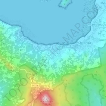
Name: Tsimkoura topographic map, elevation, terrain.

Location: Tsimkoura, Chirongui, Mayotte, 97620, France (-12.95939 45.11689 -12.91939 45.15689)

Average elevation: 93 m

Minimum elevation: 0 m

Maximum elevation: 504 m

Other topographic maps

Click on a map to view its topography, its elevation and its terrain.

Mamoudzou

France > Mayotte

Average elevation: 59 m

Tsingoni

France > Mayotte

Average elevation: 64 m

Koungou

France > Mayotte

Average elevation: 79 m

Sada

France > Mayotte

Average elevation: 29 m

Chirongui

France > Mayotte

Average elevation: 87 m

Dzaoudzi

France > Mayotte

Average elevation: 4 m

Pamandzi

France > Mayotte

Average elevation: 11 m

Dembéni

France > Mayotte

Average elevation: 105 m

Bouéni

France > Mayotte

Average elevation: 23 m

Bandraboua

France > Mayotte

Average elevation: 78 m

Mtsamboro

France > Mayotte

The village of Mtsamboro lies on the northwest coast of the island along National Road 1. To the northeast is the village of Mtsahara and to the southwest is Mtsangadoua. Two small peninsulas jut out in the village area, the larger of which lies roughly a mile north of the village centre and separates the main…

Average elevation: 48 m

Ouangani

France > Mayotte

Average elevation: 166 m

Mayotte

France > Mayotte

Average elevation: 27 m

Chiconi

France > Mayotte

Average elevation: 65 m

Gear up for your next adventure:

🔥Camping Stove - Portable stoves to cook outdoors with ease
🥾Hiking Shorts - Breathable shorts suitable for summer hikes
🚑Survival Whistle - Signal for help across long distances in mountains
🛌Insulated Sleeping Pad - Critical thermal barrier between you and the cold ground
🔦LED Flashlight - Powerful and long-lasting flashlight for camping and emergencies

As an Amazon Associate, this site earns from qualifying purchases at no extra cost to you.