Geolocate

Tsingoni topographic map

Click on the map to display elevation.

About this map

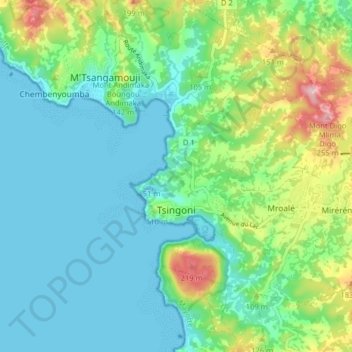
Name: Tsingoni topographic map, elevation, terrain.

Location: Tsingoni, Mayotte, 97680, France (-12.81022 45.09346 -12.75438 45.17315)

Average elevation: 64 m

Minimum elevation: 0 m

Maximum elevation: 253 m

Other topographic maps

Click on a map to view its topography, its elevation and its terrain.

Hagnoundrou

France > Mayotte > Bouéni

Average elevation: 28 m

Tsimkoura

France > Mayotte

Average elevation: 93 m

Gear up for your next adventure:

🥾Light Hiking Boots - Lightweight and comfortable boots for day hikes
🧥Waterproof Hiking Jacket - Protect yourself from rain and wind while hiking
💧Hydration Bladder - Hands-free hydration solution for long treks
🔋Lithium AA Batteries - Long-lasting power that performs in extreme cold
🧦Hiking Socks - Moisture-wicking and comfortable socks for long hikes

As an Amazon Associate, this site earns from qualifying purchases at no extra cost to you.