Geolocate

Pamandzi topographic map

Click on the map to display elevation.

About this map

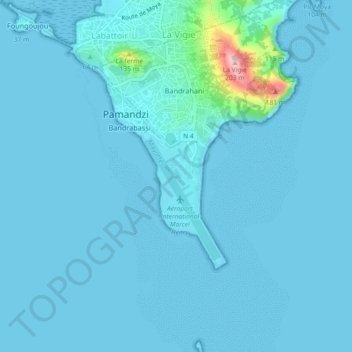
Name: Pamandzi topographic map, elevation, terrain.

Location: Pamandzi, Mayotte, 97615, France (-12.82864 45.27120 -12.78395 45.29710)

Average elevation: 11 m

Minimum elevation: 0 m

Maximum elevation: 199 m

Other topographic maps

Click on a map to view its topography, its elevation and its terrain.

Hagnoundrou

France > Mayotte > Bouéni

Average elevation: 28 m

Tsimkoura

France > Mayotte

Average elevation: 93 m

Gear up for your next adventure:

🥾Waterproof Hiking Shoes - Durable shoes for wet and rugged trails
🧣Evaporative Cooling Towel - Beat the heat during intense summer climbs
🕶️Polarized Sunglasses - Protect your eyes with durable polarized lenses
🧴First Aid Kit - Essential first aid supplies for outdoor emergencies
💧Reusable Water Bottle - Durable water bottles for hydration on trails

As an Amazon Associate, this site earns from qualifying purchases at no extra cost to you.