
Make a donation
Gear up for your next adventure:
As an Amazon Associate, this site earns from qualifying purchases at no extra cost to you.
Swalwell topographic map
Click on the map to display elevation.
Make a donation
Gear up for your next adventure:
As an Amazon Associate, this site earns from qualifying purchases at no extra cost to you.
About this map
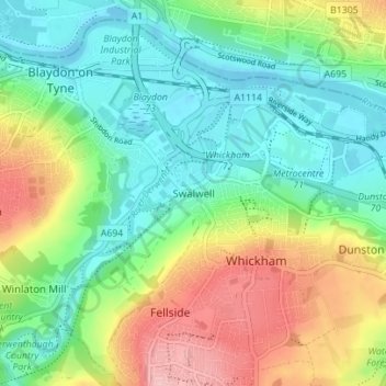
Name: Swalwell topographic map, elevation, terrain.
Average elevation: 53 m
Minimum elevation: -4 m
Maximum elevation: 152 m
Make a donation
Gear up for your next adventure:
As an Amazon Associate, this site earns from qualifying purchases at no extra cost to you.
Other topographic maps
Click on a map to view its topography, its elevation and its terrain.
Silverhill Wood
United Kingdom > England > Tyne and Wear > Gateshead > Lamesley
Average elevation: 123 m
Winlaton Mill Millennium Green
United Kingdom > England > Tyne and Wear > Gateshead > Winlaton Mill
Average elevation: 75 m
Make a donation
Gear up for your next adventure:
As an Amazon Associate, this site earns from qualifying purchases at no extra cost to you.