Geolocate

Lamesley topographic map

Click on the map to display elevation.

About this map

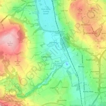
Name: Lamesley topographic map, elevation, terrain.

Location: Lamesley, Kibblesworth, Gateshead, Tyne and Wear, North East, England, United Kingdom (54.87877 -1.67812 54.93554 -1.56002)

Average elevation: 86 m

Minimum elevation: -5 m

Maximum elevation: 215 m

Other topographic maps

Click on a map to view its topography, its elevation and its terrain.

Winlaton

United Kingdom > England > Tyne and Wear > Gateshead

Average elevation: 76 m

Sunniside

United Kingdom > England > Tyne and Wear > Gateshead

Average elevation: 142 m

Black Hill

United Kingdom > England > Tyne and Wear > Gateshead

Average elevation: 125 m

Sheriff Hill

United Kingdom > England > Tyne and Wear > Gateshead

Average elevation: 118 m

Swalwell

United Kingdom > England > Tyne and Wear > Gateshead

Average elevation: 53 m

Pelaw

United Kingdom > England > Tyne and Wear > Gateshead > Pelaw

Average elevation: 51 m

Stella Wood

United Kingdom > England > Tyne and Wear > Gateshead > Stella

Average elevation: 49 m

Swalwell

United Kingdom > England > Tyne and Wear > Gateshead

Average elevation: 53 m

Gear up for your next adventure:

🧦Hiking Socks - Moisture-wicking and comfortable socks for long hikes
🛁Quick-Dry Microfiber Towel - Space-saving towel that dries rapidly on the move
🥾Trekking Poles - Adjustable trekking poles to reduce knee stress and improve stability
🌡️Emergency Mylar Blankets - Compact thermal protection for unexpected nights outdoors
🎒Hiking Backpack - Lightweight and ergonomic backpacks for day hikes or multi-day treks

As an Amazon Associate, this site earns from qualifying purchases at no extra cost to you.