
Peppara Dam topographic map
Interactive map
Click on the map to display elevation.
About this map
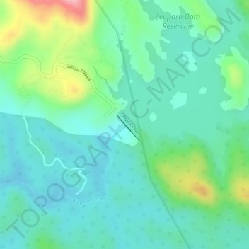
Name: Peppara Dam topographic map, elevation, terrain.
Location: Peppara Dam, Nedumangad, Thiruvananthapuram, Kerala, India (8.62293 77.13796 8.62303 77.13806)
Average elevation: 119 m
Minimum elevation: 74 m
Maximum elevation: 237 m
Other topographic maps
Click on a map to view its topography, its elevation and its terrain.
Wildlife Sanctuary, Peppara
India > Kerala > Nedumangad
Wildlife Sanctuary, Peppara, Nedumangad, Thiruvananthapuram, Kerala, India
Average elevation: 539 m
Nedumangad
India > Kerala > Nedumangad > Nedumangad
Nedumangad, Thiruvananthapuram, Kerala, 695544, India
Average elevation: 81 m