
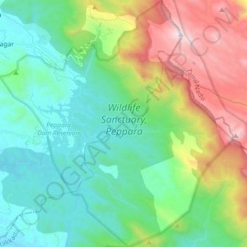
Wildlife Sanctuary, Peppara topographic map
Interactive map
Click on the map to display elevation.
About this map
Name: Wildlife Sanctuary, Peppara topographic map, elevation, terrain.
Average elevation: 539 m
Minimum elevation: 59 m
Maximum elevation: 1,685 m
Other topographic maps
Click on a map to view its topography, its elevation and its terrain.
Peppara Dam
India > Kerala > Nedumangad
Peppara Dam, Nedumangad, Thiruvananthapuram, Kerala, India
Average elevation: 119 m
Nedumangad
India > Kerala > Nedumangad > Nedumangad
Nedumangad, Thiruvananthapuram, Kerala, 695544, India
Average elevation: 81 m