
Thank you for supporting this site ❤️
Make a donation
Make a donation
Gear up for your next adventure:
As an Amazon Associate, this site earns from qualifying purchases at no extra cost to you.
Nedumangad topographic map
Click on the map to display elevation.
Thank you for supporting this site ❤️
Make a donation
Make a donation
Gear up for your next adventure:
As an Amazon Associate, this site earns from qualifying purchases at no extra cost to you.
Nedumangad
Nedumangad is located at 8°36′N 77°00′E / 8.6°N 77.0°E / 8.6; 77.0. It has an average elevation of 68 metres (223 feet).
Thank you for supporting this site ❤️
Make a donation
Make a donation
Gear up for your next adventure:
As an Amazon Associate, this site earns from qualifying purchases at no extra cost to you.
About this map
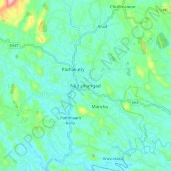
Name: Nedumangad topographic map, elevation, terrain.
Location: Nedumangad, Thiruvananthapuram, Kerala, 695544, India (8.56522 76.96298 8.64522 77.04298)
Average elevation: 81 m
Minimum elevation: 31 m
Maximum elevation: 289 m
Thank you for supporting this site ❤️
Make a donation
Make a donation
Gear up for your next adventure:
As an Amazon Associate, this site earns from qualifying purchases at no extra cost to you.