Geolocate

Caryhurst topographic map

Click on the map to display elevation.

About this map

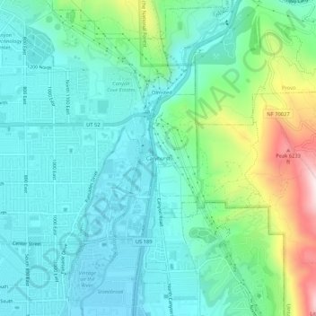
Name: Caryhurst topographic map, elevation, terrain.

Location: Caryhurst, Provo, Utah County, Utah, 84604, United States (40.28773 -111.67464 40.32773 -111.63464)

Average elevation: 1,563 m

Minimum elevation: 1,438 m

Maximum elevation: 1,974 m

Gear up for your next adventure:

💡LED Headlamp - Hands-free illumination for night hiking and camping
🥾Trail Hiking Shoes - Durable shoes designed for rugged trails
💧Filtered Water Bottle - Safe drinking water on the go
Bushcraft Tarp - Versatile emergency shelter or gear protection
👟Trail Running Shoes - Agile footwear for fast-paced topographic exploration

As an Amazon Associate, this site earns from qualifying purchases at no extra cost to you.