Geolocate

Unterägeri topographic map

Click on the map to display elevation.

About this map

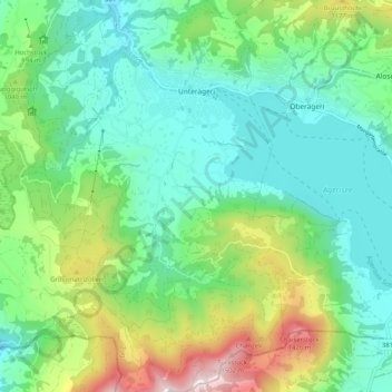
Name: Unterägeri topographic map, elevation, terrain.

Location: Unterägeri, Zug, 6314, Switzerland (47.08395 8.54167 47.15344 8.62156)

Average elevation: 922 m

Minimum elevation: 678 m

Maximum elevation: 1,563 m

Other topographic maps

Click on a map to view its topography, its elevation and its terrain.

Gottschalkenberg

Switzerland > Zug > Menzingen

Average elevation: 1,005 m

Zugerberg

Switzerland > Zug > Zug > Schönfels

Average elevation: 808 m

Allenwinden

Switzerland > Zug > Baar

Average elevation: 730 m

Morgarten

Switzerland > Zug > Oberägeri

Average elevation: 892 m

Wildspitz

Switzerland > Zug > Unterägeri

Average elevation: 1,266 m

Edlibach

Switzerland > Zug

Average elevation: 693 m

Gear up for your next adventure:

🥾All-Terrain Hiking Boots - Versatile boots for varied hiking conditions
🥾Hiking Boots - Sturdy boots providing ankle support and traction on rugged trails
🦯Trekking Poles - Reduced impact on joints for steep topographic climbs
🥾Mountain Hiking Shoes - Shoes with superior grip for mountainous terrain
🧥Waterproof Pants - Keep dry during rainy hiking conditions

As an Amazon Associate, this site earns from qualifying purchases at no extra cost to you.