Geolocate

Tungka topographic map

Click on the map to display elevation.

About this map

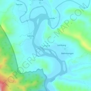
Name: Tungka topographic map, elevation, terrain.

Location: Tungka, Enrekang, South Sulawesi, Sulawesi, 91712, Indonesia (-3.53870 119.71466 -3.49870 119.75466)

Average elevation: 120 m

Minimum elevation: 51 m

Maximum elevation: 473 m

Other topographic maps

Click on a map to view its topography, its elevation and its terrain.

Baraka

Indonesia > South Sulawesi > Enrekang

Average elevation: 827 m

Bungin

Indonesia > South Sulawesi > Enrekang

Average elevation: 1,238 m

Buntu Batu

Indonesia > South Sulawesi > Enrekang

Average elevation: 1,459 m

Cendana

Indonesia > South Sulawesi > Enrekang

Average elevation: 152 m

Maiwa

Indonesia > South Sulawesi > Enrekang

Average elevation: 214 m

Malua

Indonesia > South Sulawesi > Enrekang

Average elevation: 709 m

Malua

Indonesia > South Sulawesi > Enrekang

Average elevation: 709 m

Alla

Indonesia > South Sulawesi > Enrekang

Average elevation: 1,037 m

Gear up for your next adventure:

🔦LED Headtorch - Bright and durable light for night activities
🧥Softshell Hiking Jacket - The perfect balance of wind protection and breathability
📷Outdoor Action Camera - Capture high-elevation views and rugged adventures
🦶Anti-Blister Balm - Prevents friction and hotspots during long ascents
💧Collapsible Water Bottle - Space-saving water bottle for outdoor activities

As an Amazon Associate, this site earns from qualifying purchases at no extra cost to you.