
Make a donation
Gear up for your next adventure:
As an Amazon Associate, this site earns from qualifying purchases at no extra cost to you.
Cullybackey topographic map
Click on the map to display elevation.
Make a donation
Gear up for your next adventure:
As an Amazon Associate, this site earns from qualifying purchases at no extra cost to you.
About this map
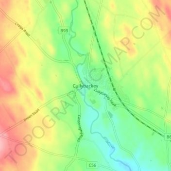
Name: Cullybackey topographic map, elevation, terrain.
Average elevation: 92 m
Minimum elevation: 41 m
Maximum elevation: 156 m
Make a donation
Gear up for your next adventure:
As an Amazon Associate, this site earns from qualifying purchases at no extra cost to you.
Other topographic maps
Click on a map to view its topography, its elevation and its terrain.
Make a donation
Gear up for your next adventure:
As an Amazon Associate, this site earns from qualifying purchases at no extra cost to you.
Loughgiel Millennium Centre
United Kingdom > Northern Ireland > County Antrim > Loughguile
Average elevation: 155 m
Causeway Coast AONB
United Kingdom > Northern Ireland > County Antrim > Ballintoy
Average elevation: 34 m
Make a donation
Gear up for your next adventure:
As an Amazon Associate, this site earns from qualifying purchases at no extra cost to you.
Shane's Castle Park
United Kingdom > Northern Ireland > County Antrim > Randalstown
Average elevation: 30 m
Make a donation
Gear up for your next adventure:
As an Amazon Associate, this site earns from qualifying purchases at no extra cost to you.
Lagan Navigation (Abandoned)
United Kingdom > Northern Ireland > County Antrim > Belfast
Average elevation: 29 m
Mid and East Antrim District
United Kingdom > Northern Ireland > County Antrim
Average elevation: 111 m
Antrim and Newtownabbey District
United Kingdom > Northern Ireland > County Antrim
Average elevation: 97 m
Make a donation
Gear up for your next adventure:
As an Amazon Associate, this site earns from qualifying purchases at no extra cost to you.
Kinbane Castle
United Kingdom > Northern Ireland > County Antrim > Ballycastle
Average elevation: 37 m
Make a donation
Gear up for your next adventure:
As an Amazon Associate, this site earns from qualifying purchases at no extra cost to you.
Mid and East Antrim District
United Kingdom > Northern Ireland > County Antrim
Average elevation: 111 m
Make a donation
Gear up for your next adventure:
As an Amazon Associate, this site earns from qualifying purchases at no extra cost to you.
Make a donation
Gear up for your next adventure:
As an Amazon Associate, this site earns from qualifying purchases at no extra cost to you.
Antrim and Newtownabbey District
United Kingdom > Northern Ireland > County Antrim
Average elevation: 97 m
Make a donation
Gear up for your next adventure:
As an Amazon Associate, this site earns from qualifying purchases at no extra cost to you.
Mid and East Antrim District
United Kingdom > Northern Ireland > County Antrim
Average elevation: 111 m
Make a donation
Gear up for your next adventure:
As an Amazon Associate, this site earns from qualifying purchases at no extra cost to you.
Make a donation
Gear up for your next adventure:
As an Amazon Associate, this site earns from qualifying purchases at no extra cost to you.
Antrim and Newtownabbey District
United Kingdom > Northern Ireland > County Antrim
Average elevation: 97 m