
Kampung Sahom topographic map
Interactive map
Click on the map to display elevation.
About this map
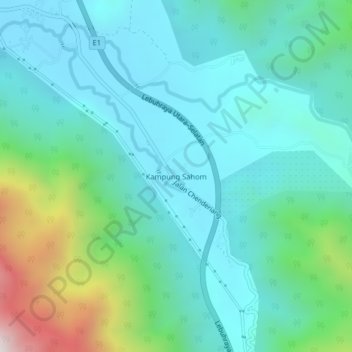
Name: Kampung Sahom topographic map, elevation, terrain.
Location: Kampung Sahom, Kampar, Perak, Malaysia (4.34869 101.20700 4.38869 101.24700)
Average elevation: 271 m
Minimum elevation: 38 m
Maximum elevation: 1,143 m
Other topographic maps
Click on a map to view its topography, its elevation and its terrain.
Pantai Ban Pecah
Malaysia > Perak > Kuala Kurau
Pantai Ban Pecah, Jalan Pantai, Kuala Kurau, Kerian, Perak, 34350, Malaysia
Average elevation: 2 m
Seri Iskandar
Malaysia > Perak > Seri Iskandar
Seri Iskandar, Perak Tengah, Perak, 32610, Malaysia
Average elevation: 29 m