Geolocate

Kampar topographic map

Click on the map to display elevation.

About this map

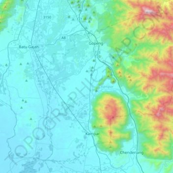
Name: Kampar topographic map, elevation, terrain.

Location: Kampar, Perak, Malaysia (4.24639 101.04945 4.53802 101.38700)

Average elevation: 247 m

Minimum elevation: 2 m

Maximum elevation: 1,673 m

Other topographic maps

Click on a map to view its topography, its elevation and its terrain.

Ipoh

Malaysia > Perak

Average elevation: 205 m

Pantai Ban Pecah

Malaysia > Perak > Kuala Kurau

Average elevation: 2 m

Kampung Sahom

Malaysia > Perak

Average elevation: 271 m

Gopeng

Malaysia > Perak

Average elevation: 120 m

Kampung Timah

Malaysia > Perak

Average elevation: 21 m

Gear up for your next adventure:

🚑Survival Whistle - Signal for help across long distances in mountains
🧥Insulated Jacket - Keep warm in cold outdoor conditions
🧢Hiking Hat - Sun-protective and breathable hats for long treks
👟Trail Running Shoes - Agile footwear for fast-paced topographic exploration
🚲Handlebar Phone Mount - View topographic-map.com live while cycling

As an Amazon Associate, this site earns from qualifying purchases at no extra cost to you.