Geolocate

Gopeng topographic map

Click on the map to display elevation.

About this map

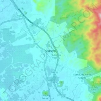
Name: Gopeng topographic map, elevation, terrain.

Location: Gopeng, Kampar, Perak, 31600, Malaysia (4.43679 101.12808 4.51679 101.20808)

Average elevation: 120 m

Minimum elevation: 31 m

Maximum elevation: 646 m

Other topographic maps

Click on a map to view its topography, its elevation and its terrain.

Bukit Merah Lake

Malaysia > Perak

Average elevation: 10 m

Kampar

Malaysia > Perak

Average elevation: 247 m

Temenggor Lake

Malaysia > Perak

Average elevation: 639 m

Gear up for your next adventure:

🔭Compact Monocular - One-handed bird watching and trail spotting
🥾Trail Running Shoes - Lightweight and durable shoes for trail running
👖Convertible Hiking Pants - Zip-off legs to adapt to changing weather conditions
💧Filtered Water Bottle - Safe drinking water on the go
👟Sport Hiking Sandals - Breathable footwear for water crossings and camp rest

As an Amazon Associate, this site earns from qualifying purchases at no extra cost to you.