Geolocate

Puno topographic map

Click on the map to display elevation.

About this map

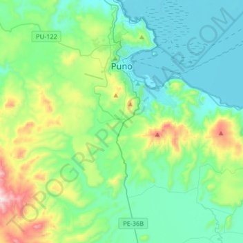
Name: Puno topographic map, elevation, terrain.

Location: Puno, Province of Puno, Puno, 05151, Peru (-16.02410 -70.18442 -15.77385 -69.91987)

Average elevation: 4,010 m

Minimum elevation: 3,807 m

Maximum elevation: 4,746 m

Other topographic maps

Click on a map to view its topography, its elevation and its terrain.

Allin Qhapaq

Peru > Puno > Macusani

Average elevation: 5,325 m

Luquina Chico

Peru > Puno

Average elevation: 3,865 m

Chillihua

Peru > Puno > Nuñoa

Average elevation: 4,610 m

Arica

Peru > Puno > San Gabán

Average elevation: 1,032 m

Macusani

Peru > Puno > Macusani

Average elevation: 4,508 m

Cunurana

Peru > Puno > Santa Rosa

Average elevation: 4,912 m

Ananta

Peru > Puno > Ituata > Ananta

Average elevation: 4,645 m

Juliaca

Peru > Puno > Juliaca

Average elevation: 3,861 m

San Fracisco

Peru > Puno > Putina

Average elevation: 3,902 m

Saman

Peru > Puno > Samán

Average elevation: 3,824 m

Gear up for your next adventure:

🥾Mountain Trail Shoes - High-traction shoes for mountain trails
💡LED Headlamp - Hands-free illumination for night hiking and camping
🧰Multitool Knife - Compact and versatile tool for outdoor use
🥾Trekking Boots - Durable boots for long-distance trekking
🥾Waterproof Hiking Shoes - Durable shoes for wet and rugged trails

As an Amazon Associate, this site earns from qualifying purchases at no extra cost to you.