
Make a donation
Gear up for your next adventure:
As an Amazon Associate, this site earns from qualifying purchases at no extra cost to you.
Bichlbach topographic map
Click on the map to display elevation.
Make a donation
Gear up for your next adventure:
As an Amazon Associate, this site earns from qualifying purchases at no extra cost to you.
About this map
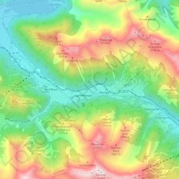
Name: Bichlbach topographic map, elevation, terrain.
Location: Bichlbach, Bezirk Reutte, Tirol, 6621, Österreich (47.39482 10.76056 47.44591 10.87409)
Average elevation: 1,492 m
Minimum elevation: 969 m
Maximum elevation: 2,372 m
Make a donation
Gear up for your next adventure:
As an Amazon Associate, this site earns from qualifying purchases at no extra cost to you.
Other topographic maps
Click on a map to view its topography, its elevation and its terrain.
Make a donation
Gear up for your next adventure:
As an Amazon Associate, this site earns from qualifying purchases at no extra cost to you.
Make a donation
Gear up for your next adventure:
As an Amazon Associate, this site earns from qualifying purchases at no extra cost to you.
Weißenbach am Lech
Österreich > Tirol > Bezirk Reutte > Gemeinde Weißenbach am Lech
Average elevation: 1,047 m
Gessebach
Österreich > Tirol > Bezirk Reutte > Gemeinde Nesselwängle > Haller
Average elevation: 1,362 m
Make a donation
Gear up for your next adventure:
As an Amazon Associate, this site earns from qualifying purchases at no extra cost to you.
Geierköpfe-Ostgipfel
Österreich > Tirol > Bezirk Reutte > Marktgemeinde Reutte
Der Aufstieg vom Plansee weist wegen der Verluste über 1200 Höhenmeter auf und dauert drei bis vier Stunden. Es handelt sich um eine leichte Bergtour, bei der man nur an einer einzigen Stelle kurz vor dem Gipfel auch Hand anlegen muss.
Average elevation: 1,590 m