
Make a donation
Gear up for your next adventure:
As an Amazon Associate, this site earns from qualifying purchases at no extra cost to you.
Rinnen topographic map
Click on the map to display elevation.
Make a donation
Gear up for your next adventure:
As an Amazon Associate, this site earns from qualifying purchases at no extra cost to you.
About this map
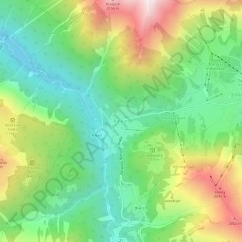
Name: Rinnen topographic map, elevation, terrain.
Location: Rinnen, Berwang, Bezirk Reutte, Tirol, 6622, Österreich (47.38474 10.69760 47.42474 10.73760)
Average elevation: 1,498 m
Minimum elevation: 1,057 m
Maximum elevation: 2,256 m
Make a donation
Gear up for your next adventure:
As an Amazon Associate, this site earns from qualifying purchases at no extra cost to you.
Other topographic maps
Click on a map to view its topography, its elevation and its terrain.
Pfafflar
Österreich > Tirol > Bezirk Reutte
Die Siedler rodeten Wald, um Wiesen für Viehzucht (Ziegen, Schafe, Kühe) und Ackerbau (Kartoffeln, Getreide, Flachs und Bohnen) zu bekommen. Somit waren sie wirtschaftlich unabhängig. Damals war das Leben in den Bergen ein harter Überlebenskampf. Die Bergwiesen wurden zum Teil bis auf 2.300 m Höhe…
Average elevation: 1,814 m
Make a donation
Gear up for your next adventure:
As an Amazon Associate, this site earns from qualifying purchases at no extra cost to you.
Gessebach
Österreich > Tirol > Bezirk Reutte > Gemeinde Nesselwängle > Haller
Average elevation: 1,362 m
Gemeinde Pflach
Österreich > Tirol > Bezirk Reutte
Die Gemeinde Pflach liegt im Reuttener Becken und erstreckt sich über eine Fläche von rund vierzehn Quadratkilometer. Vom Lech, in einer Höhe von 840 Meter über dem Meer, steigt das Land bewaldet nach Westen auf 1500 und im Osten auf über 2048 Meter zum Säuling an. Über siebzig Prozent der Fläche sind…
Average elevation: 1,084 m
Make a donation
Gear up for your next adventure:
As an Amazon Associate, this site earns from qualifying purchases at no extra cost to you.