
Thank you for supporting this site ❤️
Make a donation
Make a donation
Gear up for your next adventure:
As an Amazon Associate, this site earns from qualifying purchases at no extra cost to you.
Häselgehr topographic map
Click on the map to display elevation.
Thank you for supporting this site ❤️
Make a donation
Make a donation
Gear up for your next adventure:
As an Amazon Associate, this site earns from qualifying purchases at no extra cost to you.
About this map
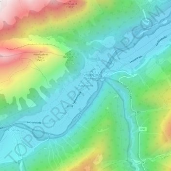
Name: Häselgehr topographic map, elevation, terrain.
Location: Häselgehr, Bezirk Reutte, Tirol, 6651, Österreich (47.28723 10.46848 47.32723 10.50848)
Average elevation: 1,327 m
Minimum elevation: 982 m
Maximum elevation: 2,219 m
Thank you for supporting this site ❤️
Make a donation
Make a donation
Gear up for your next adventure:
As an Amazon Associate, this site earns from qualifying purchases at no extra cost to you.