
Hickling topographic map
Click on the map to display elevation.
About this map
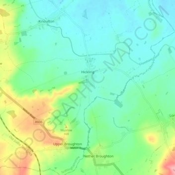
Name: Hickling topographic map, elevation, terrain.
Location: Hickling, Rushcliffe, Nottinghamshire, England, United Kingdom (52.83211 -1.03346 52.86347 -0.93868)
Average elevation: 66 m
Minimum elevation: 36 m
Maximum elevation: 144 m
Other topographic maps
Click on a map to view its topography, its elevation and its terrain.
Stanton on the Wolds
United Kingdom > England > Nottinghamshire > Rushcliffe > Stanton on the Wolds
Average elevation: 78 m
Bassingfield
United Kingdom > England > Nottinghamshire > Rushcliffe > Holme Pierrepont > Bassingfield
Average elevation: 28 m
Archers Lake
United Kingdom > England > Nottinghamshire > Rushcliffe > Bingham
Average elevation: 28 m