
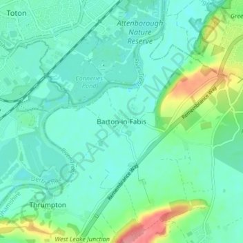
Barton-in-Fabis topographic map
Interactive map
Click on the map to display elevation.
About this map
Name: Barton-in-Fabis topographic map, elevation, terrain.
Average elevation: 37 m
Minimum elevation: 18 m
Maximum elevation: 100 m
Other topographic maps
Click on a map to view its topography, its elevation and its terrain.
Ratcliffe on Soar
United Kingdom > England > Nottinghamshire > Rushcliffe
Ratcliffe on Soar, Rushcliffe, Nottinghamshire, England, United Kingdom
Average elevation: 36 m
West Bridgford
United Kingdom > England > Nottinghamshire > Rushcliffe
West Bridgford, Rushcliffe, Nottinghamshire, England, NG2 6BT, United Kingdom
Average elevation: 39 m
Willoughby on the Wolds
United Kingdom > England > Nottinghamshire > Rushcliffe
Willoughby on the Wolds, Rushcliffe, Nottinghamshire, England, United Kingdom
Average elevation: 92 m
Gotham
United Kingdom > England > Nottinghamshire > Rushcliffe
Gotham, Rushcliffe, Nottinghamshire, England, United Kingdom
Average elevation: 49 m
Widmerpool
United Kingdom > England > Nottinghamshire > Rushcliffe
Widmerpool, Rushcliffe, Nottinghamshire, England, United Kingdom
Average elevation: 77 m
Keyworth
United Kingdom > England > Nottinghamshire > Rushcliffe
Keyworth, Rushcliffe, Nottinghamshire, England, United Kingdom
Average elevation: 68 m
Radcliffe on Trent
United Kingdom > England > Nottinghamshire > Rushcliffe
Radcliffe on Trent, Rushcliffe, Nottinghamshire, England, United Kingdom
Average elevation: 37 m
Flintham
United Kingdom > England > Nottinghamshire > Rushcliffe
Flintham, Rushcliffe, Nottinghamshire, England, NG23 5LA, United Kingdom
Average elevation: 35 m
West Bridgford
United Kingdom > England > Nottinghamshire > Rushcliffe
West Bridgford, Rushcliffe, Nottinghamshire, England, United Kingdom
Average elevation: 36 m
Bassingfield
United Kingdom > England > Nottinghamshire > Rushcliffe > Holme Pierrepont > Bassingfield
Bassingfield, Holme Pierrepont, Rushcliffe, Nottinghamshire, England, NG12 2LH, United Kingdom
Average elevation: 28 m
Cropwell Bishop
United Kingdom > England > Nottinghamshire > Rushcliffe
Cropwell Bishop, Rushcliffe, Nottinghamshire, England, NG12 3DU, United Kingdom
Average elevation: 45 m
Ruddington
United Kingdom > England > Nottinghamshire > Rushcliffe
Ruddington, Rushcliffe, Nottinghamshire, England, United Kingdom
Average elevation: 41 m
Newton
United Kingdom > England > Nottinghamshire > Rushcliffe
Newton, Rushcliffe, Nottinghamshire, East Midlands, England, United Kingdom
Average elevation: 38 m
Orston
United Kingdom > England > Nottinghamshire > Rushcliffe > Orston
Orston, Rushcliffe, Nottinghamshire, East Midlands, England, United Kingdom
Average elevation: 27 m
Wysall
United Kingdom > England > Nottinghamshire > Rushcliffe > Wysall
Wysall, Rushcliffe, Nottinghamshire, East Midlands, England, NG12 5QN, United Kingdom
Average elevation: 73 m
Stanton on the Wolds
United Kingdom > England > Nottinghamshire > Rushcliffe > Stanton on the Wolds
Stanton on the Wolds, Rushcliffe, Nottinghamshire, East Midlands, England, NG12 5BL, United Kingdom
Average elevation: 78 m
East Bridgford
United Kingdom > England > Nottinghamshire > Rushcliffe
East Bridgford, Rushcliffe, Nottinghamshire, England, United Kingdom
Average elevation: 36 m
Stanford on Soar
United Kingdom > England > Nottinghamshire > Rushcliffe
Stanford on Soar, Rushcliffe, Nottinghamshire, England, United Kingdom
Average elevation: 61 m
Colston Bassett
United Kingdom > England > Nottinghamshire > Rushcliffe > Colston Bassett
Colston Bassett, Rushcliffe, Nottinghamshire, East Midlands, England, United Kingdom
Average elevation: 39 m
Bingham
United Kingdom > England > Nottinghamshire > Rushcliffe
Bingham, Rushcliffe, Nottinghamshire, England, United Kingdom
Average elevation: 33 m
Aslockton
United Kingdom > England > Nottinghamshire > Rushcliffe
Aslockton, Rushcliffe, Nottinghamshire, England, NG13 9AT, United Kingdom
Average elevation: 24 m
Zouch
United Kingdom > England > Nottinghamshire > Rushcliffe > Sutton Bonington
Zouch, Sutton Bonington, Rushcliffe, Nottinghamshire, England, LE12 5EQ, United Kingdom
Average elevation: 49 m
West Leake
United Kingdom > England > Nottinghamshire > Rushcliffe > West Leake
West Leake, Rushcliffe, Nottinghamshire, East Midlands, England, United Kingdom
Average elevation: 57 m
Sutton Bonington
United Kingdom > England > Nottinghamshire > Rushcliffe
Sutton Bonington, Rushcliffe, Nottinghamshire, England, United Kingdom
Average elevation: 47 m
Holme Pierrepont
United Kingdom > England > Nottinghamshire > Rushcliffe
Holme Pierrepont, Rushcliffe, Nottinghamshire, England, United Kingdom
Average elevation: 26 m
Kinoulton
United Kingdom > England > Nottinghamshire > Rushcliffe
Kinoulton, Rushcliffe, Nottinghamshire, England, United Kingdom
Average elevation: 60 m
Bunny
United Kingdom > England > Nottinghamshire > Rushcliffe
Bunny, Rushcliffe, Nottinghamshire, England, United Kingdom
Average elevation: 53 m