
Wainwright topographic map
Click on the map to display elevation.
About this map
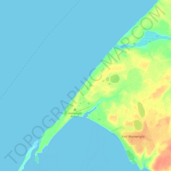
Name: Wainwright topographic map, elevation, terrain.
Location: Wainwright, North Slope, Alaska, 99782, United States (70.61122 -160.25125 70.70550 -159.80865)
Average elevation: 5 m
Minimum elevation: -4 m
Maximum elevation: 30 m
Other topographic maps
Click on a map to view its topography, its elevation and its terrain.
Deadhorse
United States > Alaska > North Slope
In February 2023, a "high altitude object" about the size of a small car was shot down near the area after a decision by President Joe Biden.
Average elevation: 15 m