Geolocate

Mesa topographic map

Click on the map to display elevation.

About this map
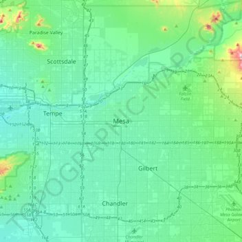
Name: Mesa topographic map, elevation, terrain.

Location: Mesa, Maricopa County, Arizona, 85201, United States (33.25510 -111.99146 33.57510 -111.67146)

Average elevation: 399 m

Minimum elevation: 317 m

Maximum elevation: 884 m

Other topographic maps

Click on a map to view its topography, its elevation and its terrain.

Goodyear

United States > Arizona > Maricopa County

Average elevation: 366 m

Tolleson

United States > Arizona > Maricopa County

Average elevation: 310 m

Hollis Park

United States > Arizona > Maricopa County > Tempe

Average elevation: 362 m

New River

United States > Arizona > Maricopa County > Phoenix

Average elevation: 690 m

Gear up for your next adventure:

🧣Merino Neck Gaiter - Protects against wind, sun, and cold at high altitudes
🧥Softshell Hiking Jacket - The perfect balance of wind protection and breathability
🧴Insect Repellent - Protect yourself from bugs during outdoor adventures
🩹Compact First Aid Kit - Pre-packed essentials for common trail injuries
🥾All-Terrain Hiking Boots - Versatile boots for varied hiking conditions

As an Amazon Associate, this site earns from qualifying purchases at no extra cost to you.