Geolocate

Caravaggio topographic map

Click on the map to display elevation.

About this map

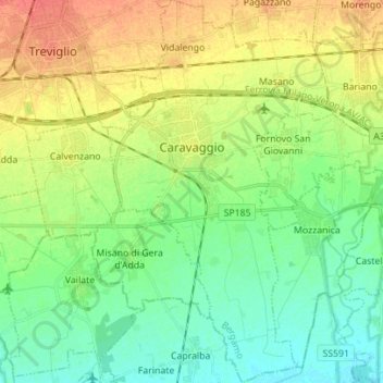
Name: Caravaggio topographic map, elevation, terrain.

Location: Caravaggio, Bergamo, Lombardy, 24043, Italy (45.43715 9.61289 45.53467 9.69486)

Average elevation: 109 m

Minimum elevation: 91 m

Maximum elevation: 136 m

Other topographic maps

Click on a map to view its topography, its elevation and its terrain.

Xino

Italy > Lombardy > Bergamo > Fonteno

Average elevation: 512 m

Tezzi Alti

Italy > Lombardy > Bergamo > Gandellino

Average elevation: 1,225 m

Bani

Italy > Lombardy > Bergamo > Ardesio

Average elevation: 1,064 m

Sogno

Italy > Lombardy > Bergamo > Torre de' Busi > San Marco

Average elevation: 842 m

Piangaiano

Italy > Lombardy > Bergamo

Average elevation: 557 m

Clanezzo

Italy > Lombardy > Bergamo > Ubiale Clanezzo

Average elevation: 401 m

Bani

Italy > Lombardy > Bergamo > Ardesio

Average elevation: 1,064 m

Borghetto

Italy > Lombardy > Bergamo > Burligo

Average elevation: 522 m

Tiglio

Italy > Lombardy > Bergamo > Zogno

Average elevation: 621 m

Lizzola

Italy > Lombardy > Bergamo

Average elevation: 1,517 m

Bondione

Italy > Lombardy > Bergamo > Lizzola

Average elevation: 1,457 m

Gear up for your next adventure:

Lightweight Camping Tent - Portable shelter optimized for Canadian backcountry camping
🛶Kayak Accessories - Essential gear for safe and fun kayaking adventures
🥫Freeze-Dried Meals - Lightweight, high-calorie nutrition for multi-day treks
🥾Lightweight Hiking Boots - Boots for comfort and mobility on long hikes
🎒Backpack Rain Cover - External shield to keep your entire pack dry

As an Amazon Associate, this site earns from qualifying purchases at no extra cost to you.