Geolocate

New Hope topographic map

Click on the map to display elevation.

About this map

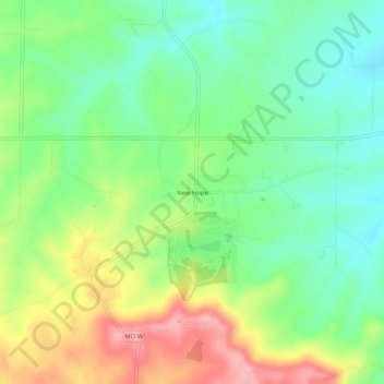
Name: New Hope topographic map, elevation, terrain.

Location: New Hope, Lincoln County, Missouri, United States (39.11671 -90.88430 39.15671 -90.84430)

Average elevation: 222 m

Minimum elevation: 173 m

Maximum elevation: 299 m

Other topographic maps

Click on a map to view its topography, its elevation and its terrain.

Troy

United States > Missouri > Lincoln County

Average elevation: 172 m

Winfield

United States > Missouri > Lincoln County

Average elevation: 143 m

Silex

United States > Missouri > Lincoln County

Average elevation: 173 m

Elsberry

United States > Missouri > Lincoln County

Average elevation: 142 m

Truxton

United States > Missouri > Lincoln County

Average elevation: 216 m

Moscow Mills

United States > Missouri > Lincoln County

Average elevation: 153 m

Gear up for your next adventure:

🧥Waterproof Jacket - Lightweight rain jackets for hiking and outdoor activities
🥾Hiking Leggings - Comfortable leggings for outdoor activities
👟Trail Running Shoes - Agile footwear for fast-paced topographic exploration
🧼Travel Hand Sanitizer - Keep hands clean when water is scarce
🕯️Camping Lantern - Illuminates your entire campsite with high-efficiency LEDs

As an Amazon Associate, this site earns from qualifying purchases at no extra cost to you.