Geolocate

Silex topographic map

Click on the map to display elevation.

About this map

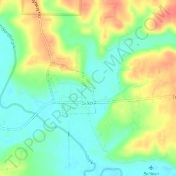
Name: Silex topographic map, elevation, terrain.

Location: Silex, Lincoln County, Missouri, United States (39.12162 -91.06233 39.12964 -91.05278)

Average elevation: 173 m

Minimum elevation: 149 m

Maximum elevation: 207 m

Other topographic maps

Click on a map to view its topography, its elevation and its terrain.

New Hope

United States > Missouri > Lincoln County

Average elevation: 222 m

Gear up for your next adventure:

🚲MTB Frame Bag - Carry tools and maps directly on your bicycle frame
🧥Ultralight Puffy Jacket - Maximum warmth that packs down to the size of an orange
🧦Hiking Socks - Moisture-wicking and comfortable socks for long hikes
🧴Bear Spray Holster - Quick-access carry for essential Canadian wilderness safety
🛁Quick-Dry Microfiber Towel - Space-saving towel that dries rapidly on the move

As an Amazon Associate, this site earns from qualifying purchases at no extra cost to you.