Geolocate

Maastricht topographic map

Click on the map to display elevation.

About this map

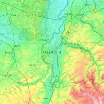
Name: Maastricht topographic map, elevation, terrain.

Location: Maastricht, Limburg, Netherlands, 6211CS, Netherlands (50.69124 5.53098 51.01124 5.85098)

Average elevation: 101 m

Minimum elevation: 28 m

Maximum elevation: 328 m

Other topographic maps

Click on a map to view its topography, its elevation and its terrain.

Meuse

Netherlands > Limburg > Maastricht > Borgharen

Average elevation: 48 m

Gear up for your next adventure:

🧦Merino Wool Socks - Moisture-wicking comfort for long-distance hiking
🧥Ultralight Puffy Jacket - Maximum warmth that packs down to the size of an orange
🥾Hiking Boots - Sturdy boots providing ankle support and traction on rugged trails
🧴First Aid Kit - Essential first aid supplies for outdoor emergencies
🥾All-Terrain Hiking Boots - Versatile boots for varied hiking conditions

As an Amazon Associate, this site earns from qualifying purchases at no extra cost to you.