
Arosa topographic map
Click on the map to display elevation.
Arosa
Before 2017, the municipality was in the Schanfigg sub-district of the Plessur district, after that date it was part of the Plessur Region. Located on the south-east slope of the Weisshorn chain, the town of Arosa is at the top of the Schanfigg valley at the foot of the Aroser Weisshorn (2,653 m (8,704 ft)). Adjoining are the areas of Innerarosa, Dorf-Obersee, Untersee and Maran-Prätschli at an elevation of 1,690 and 1,950 meters (5,540 and 6,400 ft).
About this map
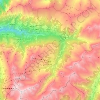
Name: Arosa topographic map, elevation, terrain.
Location: Arosa, Plessur, Grisons, Switzerland (46.72958 9.58322 46.87360 9.80700)
Average elevation: 1,985 m
Minimum elevation: 694 m
Maximum elevation: 2,959 m
Other topographic maps
Click on a map to view its topography, its elevation and its terrain.
Haldenstein
Switzerland > Grisons > Plessur > Chur
Before 2017, the municipality was located in the Fünf Dörfer sub-district of the Landquart district, after 2017 it was part of the Plessur Region. It is located north of Chur and on the left bank of the Rhine River. It consists of the haufendorf (an irregular, unplanned and quite closely packed village,…
Average elevation: 826 m