
Innerarosa topographic map
Click on the map to display elevation.
About this map
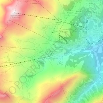
Name: Innerarosa topographic map, elevation, terrain.
Location: Innerarosa, Arosa, Plessur, Grisons, 7050, Switzerland (46.75435 9.63940 46.79435 9.67940)
Average elevation: 2,040 m
Minimum elevation: 1,611 m
Maximum elevation: 2,645 m
Other topographic maps
Click on a map to view its topography, its elevation and its terrain.
Chur
Switzerland > Grisons > Plessur
The altitude in the city area varies from 600 meters (2,000 ft) above sea level to 1,800 meters (5,900 ft) above sea level and the Churer Hausberg Brambrüesch [de] (accessible from the Old Town) is 2,174 meters (7,133 ft) above sea level.
Average elevation: 1,443 m
Chur
Switzerland > Grisons > Plessur
The altitude in the city area varies from 600 meters (2,000 ft) above sea level to 1,800 meters (5,900 ft) above sea level and the Churer Hausberg Brambrüesch (accessible from the Old Town) is 2,174 meters (7,133 ft) above sea level.
Average elevation: 1,443 m
Arosa
Switzerland > Grisons > Plessur
Before 2017, the municipality was in the Schanfigg sub-district of the Plessur district, after that date it was part of the Plessur Region. Located on the south-east slope of the Weisshorn chain, the town of Arosa is at the top of the Schanfigg valley at the foot of the Aroser Weisshorn (2,653 m (8,704 ft)).…
Average elevation: 1,985 m