
Karachi topographic map
Interactive map
Click on the map to display elevation.
About this map
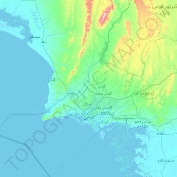
Name: Karachi topographic map, elevation, terrain.
Location: Karachi, Sindh, Pakistan (24.42735 66.28623 25.67680 67.55541)
Average elevation: 89 m
Minimum elevation: -2 m
Maximum elevation: 1,065 m
Karachi lies very close to a major fault line, where the Indian tectonic plate meets the Arabian tectonic plate. Within the city of Karachi are two small ranges: the Khasa Hills and Mulri Hills, which lie in the northwest and act as a barrier between North Nazimabad and Orangi. Karachi's hills are barren and are part of the larger Kirthar Range, and have a maximum elevation of 528 metres (1,732 feet).
Other topographic maps
Click on a map to view its topography, its elevation and its terrain.
Banglore Town
Pakistan > Sindh > Karachi Division > Gulshan-e-Iqbal Town
Banglore Town, Bahadurabad, Gulshan-e-Iqbal Town, Karachi East District, Karachi Division, Sindh, 75300, Pakistan
Average elevation: 20 m
Gadap Town
Pakistan > Sindh > Karāchi District > Karachi Division
Gadap Town, Malir District, Karachi Division, Karāchi District, Sindh, Pakistan
Average elevation: 176 m
Saddar Town
Pakistan > Sindh > Karachi South District
Saddar Town, Karachi South District, Sindh, Pakistan
Average elevation: 4 m
Gulistan-e-Jauhar
Gulistan-e-Jauhar, Gulshan Town, Sindh, 75300, Pakistan
Average elevation: 37 m
Liquatabad Town
Liquatabad Town, Karachi, Karāchi District, Sindh, 75900, Pakistan
Average elevation: 25 m
Indus River
Indus River, Lab-e-Mehran Road, Old Sukkur, Sukkur, Shikārpur District, Sindh, Pakistan
Average elevation: 64 m