
Make a donation
Gear up for your next adventure:
As an Amazon Associate, this site earns from qualifying purchases at no extra cost to you.
Montendre topographic map
Click on the map to display elevation.
Make a donation
Gear up for your next adventure:
As an Amazon Associate, this site earns from qualifying purchases at no extra cost to you.
About this map
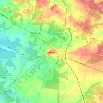
Name: Montendre topographic map, elevation, terrain.
Average elevation: 69 m
Minimum elevation: 30 m
Maximum elevation: 116 m
Make a donation
Gear up for your next adventure:
As an Amazon Associate, this site earns from qualifying purchases at no extra cost to you.
Other topographic maps
Click on a map to view its topography, its elevation and its terrain.
Grand-Village
France > Nouvelle-Aquitaine > Charente-Maritime > Le Grand-Village-Plage
Average elevation: 4 m
Make a donation
Gear up for your next adventure:
As an Amazon Associate, this site earns from qualifying purchases at no extra cost to you.
La Pommeraie des Gaillards
France > Nouvelle-Aquitaine > Charente-Maritime > Port-d'Envaux
Average elevation: 26 m
Make a donation
Gear up for your next adventure:
As an Amazon Associate, this site earns from qualifying purchases at no extra cost to you.
Saint-Nicolas
France > Nouvelle-Aquitaine > Charente-Maritime > Saint-Dizant-du-Gua
Average elevation: 14 m
Make a donation
Gear up for your next adventure:
As an Amazon Associate, this site earns from qualifying purchases at no extra cost to you.
Chiloup
France > Nouvelle-Aquitaine > Charente-Maritime > Aigrefeuille-d'Aunis
Average elevation: 23 m
Make a donation
Gear up for your next adventure:
As an Amazon Associate, this site earns from qualifying purchases at no extra cost to you.
La Ramigère Est
France > Nouvelle-Aquitaine > Charente-Maritime > Mortagne-sur-Gironde
Average elevation: 41 m
Make a donation
Gear up for your next adventure:
As an Amazon Associate, this site earns from qualifying purchases at no extra cost to you.
Les Bacheliers
France > Nouvelle-Aquitaine > Charente-Maritime > Bussac-sur-Charente
Average elevation: 25 m
La Touzetterie
France > Nouvelle-Aquitaine > Charente-Maritime > Saint-Jean-d'Angély
Average elevation: 42 m
Make a donation
Gear up for your next adventure:
As an Amazon Associate, this site earns from qualifying purchases at no extra cost to you.
La Pouchaume
France > Nouvelle-Aquitaine > Charente-Maritime > Pont-l'Abbé-d'Arnoult
Average elevation: 22 m
Make a donation
Gear up for your next adventure:
As an Amazon Associate, this site earns from qualifying purchases at no extra cost to you.
Ourse
France > Nouvelle-Aquitaine > Charente-Maritime > Saint-Germain-de-Vibrac
Average elevation: 66 m
Make a donation
Gear up for your next adventure:
As an Amazon Associate, this site earns from qualifying purchases at no extra cost to you.
Saint-Hilaire
France > Nouvelle-Aquitaine > Charente-Maritime > Dampierre-sur-Boutonne
Average elevation: 56 m
Montvollant
France > Nouvelle-Aquitaine > Charente-Maritime > Bussac-sur-Charente
Average elevation: 27 m
Make a donation
Gear up for your next adventure:
As an Amazon Associate, this site earns from qualifying purchases at no extra cost to you.
Le Gros Buisson
France > Nouvelle-Aquitaine > Charente-Maritime > Sainte-Radegonde
Average elevation: 25 m
La Motte Sureau
France > Nouvelle-Aquitaine > Charente-Maritime > Saint-Xandre
Average elevation: 17 m
Make a donation
Gear up for your next adventure:
As an Amazon Associate, this site earns from qualifying purchases at no extra cost to you.
Les Moulins
France > Nouvelle-Aquitaine > Charente-Maritime > Saint-Georges-de-Didonne
Average elevation: 10 m
Make a donation
Gear up for your next adventure:
As an Amazon Associate, this site earns from qualifying purchases at no extra cost to you.
Les Petites Cormeilles
France > Nouvelle-Aquitaine > Charente-Maritime > Dolus-d'Oléron
Average elevation: 4 m
Make a donation
Gear up for your next adventure:
As an Amazon Associate, this site earns from qualifying purchases at no extra cost to you.
Fond Lanoue
France > Nouvelle-Aquitaine > Charente-Maritime > Le Bois-Plage-en-Ré
Average elevation: 5 m
Terres du Bois du Parc
France > Nouvelle-Aquitaine > Charente-Maritime > Sainte-Même
Average elevation: 41 m
Les Bois
France > Nouvelle-Aquitaine > Charente-Maritime > Saint-Pierre-d'Oléron
Average elevation: 4 m
Make a donation
Gear up for your next adventure:
As an Amazon Associate, this site earns from qualifying purchases at no extra cost to you.
La Croix du Pouilloux
France > Nouvelle-Aquitaine > Charente-Maritime > Sainte-Lheurine
Average elevation: 60 m
Make a donation
Gear up for your next adventure:
As an Amazon Associate, this site earns from qualifying purchases at no extra cost to you.
Plage de Chef de Baie
France > Nouvelle-Aquitaine > Charente-Maritime > La Rochelle
Average elevation: 3 m
Le Berceau
France > Nouvelle-Aquitaine > Charente-Maritime > Meschers-sur-Gironde
Average elevation: 14 m
Make a donation
Gear up for your next adventure:
As an Amazon Associate, this site earns from qualifying purchases at no extra cost to you.
Le Puits Courant
France > Nouvelle-Aquitaine > Charente-Maritime > Allas-Bocage
Average elevation: 69 m
Saint-Gilles d'Oléron
France > Nouvelle-Aquitaine > Charente-Maritime > Saint-Pierre-d'Oléron
Average elevation: 7 m
Moulin de la Croix
France > Nouvelle-Aquitaine > Charente-Maritime > Saint-Pierre-d'Oléron
Average elevation: 6 m
Make a donation
Gear up for your next adventure:
As an Amazon Associate, this site earns from qualifying purchases at no extra cost to you.
Champservé le Haut
France > Nouvelle-Aquitaine > Charente-Maritime > Tonnay-Charente
Average elevation: 13 m
Champservé le Bas
France > Nouvelle-Aquitaine > Charente-Maritime > Tonnay-Charente
Average elevation: 11 m
Les Bagnes
France > Nouvelle-Aquitaine > Charente-Maritime > Saint-Pierre-d'Oléron
Average elevation: 5 m
Make a donation
Gear up for your next adventure:
As an Amazon Associate, this site earns from qualifying purchases at no extra cost to you.
La Sauzaie
France > Nouvelle-Aquitaine > Charente-Maritime > Dampierre-sur-Boutonne
Average elevation: 54 m
Make a donation
Gear up for your next adventure:
As an Amazon Associate, this site earns from qualifying purchases at no extra cost to you.
Les Biraudes
France > Nouvelle-Aquitaine > Charente-Maritime > Saint-Martin-de-Ré
Average elevation: 7 m
Le Puits d'Asnières
France > Nouvelle-Aquitaine > Charente-Maritime > Asnières-la-Giraud
Average elevation: 59 m
Make a donation
Gear up for your next adventure:
As an Amazon Associate, this site earns from qualifying purchases at no extra cost to you.
Le Breuil Malmaud
France > Nouvelle-Aquitaine > Charente-Maritime > Saint-Martin-de-Juillers
Average elevation: 65 m
Le Moulin de la Brande
France > Nouvelle-Aquitaine > Charente-Maritime > Aigrefeuille-d'Aunis
Average elevation: 21 m
Make a donation
Gear up for your next adventure:
As an Amazon Associate, this site earns from qualifying purchases at no extra cost to you.
La Fromagère
France > Nouvelle-Aquitaine > Charente-Maritime > Dompierre-sur-Mer
Average elevation: 21 m
Make a donation
Gear up for your next adventure:
As an Amazon Associate, this site earns from qualifying purchases at no extra cost to you.
Le Treuil Arnaudeau
France > Nouvelle-Aquitaine > Charente-Maritime > Saint-Médard-d'Aunis
Average elevation: 32 m
Make a donation
Gear up for your next adventure:
As an Amazon Associate, this site earns from qualifying purchases at no extra cost to you.
Make a donation
Gear up for your next adventure:
As an Amazon Associate, this site earns from qualifying purchases at no extra cost to you.
Le Maurin
France > Nouvelle-Aquitaine > Charente-Maritime > Saint-Martin-d'Ary
Average elevation: 78 m
Make a donation
Gear up for your next adventure:
As an Amazon Associate, this site earns from qualifying purchases at no extra cost to you.
Make a donation
Gear up for your next adventure:
As an Amazon Associate, this site earns from qualifying purchases at no extra cost to you.