
Make a donation
Gear up for your next adventure:
As an Amazon Associate, this site earns from qualifying purchases at no extra cost to you.
Les Martineau topographic map
Click on the map to display elevation.
Make a donation
Gear up for your next adventure:
As an Amazon Associate, this site earns from qualifying purchases at no extra cost to you.
About this map
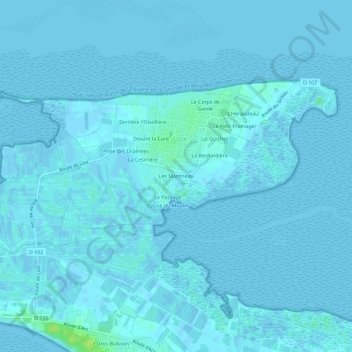
Name: Les Martineau topographic map, elevation, terrain.
Average elevation: 1 m
Minimum elevation: -3 m
Maximum elevation: 13 m
Make a donation
Gear up for your next adventure:
As an Amazon Associate, this site earns from qualifying purchases at no extra cost to you.
Other topographic maps
Click on a map to view its topography, its elevation and its terrain.
Ars-en-Ré
France > Nouvelle-Aquitaine > Charente-Maritime > Loix
Ce canton était organisé autour d'Ars-en-Ré de l'Île de Ré dans l'arrondissement de La Rochelle. Son altitude variait de 0 m (Ars-en-Ré) à 18 m (Saint-Clément-des-Baleines) pour une altitude moyenne de 4 m.
Average elevation: 1 m