Geolocate

Pike topographic map

Click on the map to display elevation.

About this map

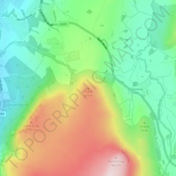
Name: Pike topographic map, elevation, terrain.

Location: Pike, Allerdale, Cumbria, England, CA12 4TE, United Kingdom (54.58678 -3.10587 54.58688 -3.10577)

Average elevation: 228 m

Minimum elevation: 83 m

Maximum elevation: 461 m

Other topographic maps

Click on a map to view its topography, its elevation and its terrain.

Kirkbampton

United Kingdom > England > Cumbria > Allerdale

Average elevation: 26 m

Greysouthen

United Kingdom > England > Cumbria > Allerdale

Average elevation: 80 m

River Ellen

United Kingdom > England > Cumbria > Allerdale > Maryport

Average elevation: 16 m

Cockshot Beck

United Kingdom > England > Cumbria > Allerdale > Torpenhow

Average elevation: 130 m

Great Clifton

United Kingdom > England > Cumbria > Allerdale

Average elevation: 62 m

The Bog

United Kingdom > England > Cumbria > Allerdale

Average elevation: 515 m

Westward

United Kingdom > England > Cumbria > Allerdale

Average elevation: 124 m

Gear up for your next adventure:

🧊Portable Cooler - Keep food and drinks cold during outdoor adventures
🪑Ultralight Camping Stool - Compact seating for rest stops during long hikes
🏕️Camping Hammock - Integrated protection for sleeping between trees
👟Trail Running Shoes - Agile footwear for fast-paced topographic exploration
🥾Trail Running Boots - Durable shoes designed for trail running

As an Amazon Associate, this site earns from qualifying purchases at no extra cost to you.